
A Dramatic Drop – Sault Ste. Marie/Wawa
by Back Roads Bill
There are many waterfalls in Northern Ontario but few have such a dramatic vertical drop as the Agawa Falls.
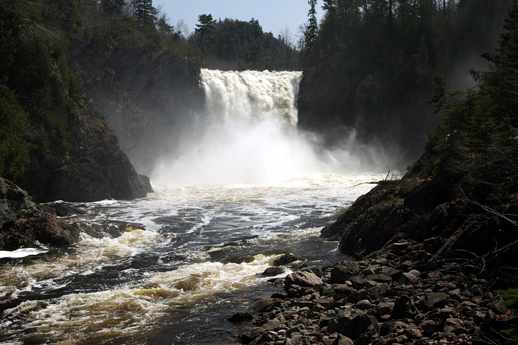
This out-of-the way 25 m waterfall is part of an experience that can be accessed in a number of ways. One is unique amongst the others and it is easier than you think. If you are looking for an experience that combines a short hike and a train ride, this one is for you!.
In nature, moving water peaks our interest. If only the Agawa River could tell us of its heritage. How was it created? Who paddled, portaged, painted and prospered from the river and its hinterland? In many ways, where you will stand and view the falls is a microcosm of Canadian history.
In the Beginning
Created 1.2 billion years ago by faulting within the area we know as the Canadian Shield, the Agawa (A-guh-wah) River was enlarged by the erosive action of millions of years of flowing water. Thanks to the volcanoes and earthquakes that moulded the Canadian Shield into towering mountains and deep canyons, and the modulating effects of four different glaciers since then, this area includes a variety of significant rock features and minerals characteristic of its rugged beauty. (Uranium, as an example, was discovered south the mouth of the river in 1948 at nearby Theano Point ; another .steertonorthernontario.ca story).
The Agawa River, like the nearby Sand River and Michipicoten River near Wawa, were extensively used by early aboriginals. It was part of their network of water trails the Ojibway call “nastawgan.” The mouths of the rivers were important summering and food gathering locations. Just north of the mouth of the Agawa is the well known Agawa Rock pictographs discovered in 1959 by researcher Selwyn Dewdney. This is also worth a stop when you visit and stay for awhile within Lake Superior Provincial Park.
From the late 1600’s many European fur traders and explorers settled on the shores of Lake Superior. During this period the mapping of the lake progressed rapidly and by 1700 its basic shape and character were a matter of record. It was the preferred way to the interior of North America. The Mississippi River was too long and the Hudson and James Bay entry points had short open water seasons, too much ice.
Pulpwood cutting began in the Algoma region in 1910 by the Lake Superior Paper Company. The lease was for ninety-nine years and remains in existence with the Ontario government. The steep contours, characteristic of the north shore rivers, were favoured by logging companies when compared to the flatter terrain on the American side of the lake with rivers having little volume of driving water. The Agawa River is a good example of a river with a sloped descent to Lake Superior. Further upstream of the falls and the canyon, the river meanders through the old granite mountains. There is a maze of small lakes and tributaries surrounded by immense stands of jack pine and spruce. This meant the original shanty men could stay in camps serviced by water rather than by tote roads.
One Man’s Vision
This appetite for trees was all because of one Philadelphia financier, Francis H. Clergue, an industrialist who kept pace with the transportation and forestry technologies of the day.
Clergue’s vision required a railway to haul resources from the interior of the Algoma District to transport logs to his pulp mill in Sault Ste. Marie and iron ore from the Helen Mine near Wawa to a proposed steel mill (which was later named Algoma Steel). The Algoma Central Railway (ACR) was chartered on August 11, 1899. The railway’s Dominion and provincial charters gave it authority to build north from Sault Ste. Marie to a junction with the Canadian Pacific Railway’s main line, as well as a branch line to Michipicoten Harbour, near Wawa to meet Clergue’s fleet of steam ships. Journeying to the falls with the ACR is a great way to experience the economic development heritage of the rail line and its original purpose.
It was a time in Canadian history where many small railway companies were bought and sold, part of our ‘National Dream.’ In 1901, Clergue acquired the charter of the Ontario, Hudson Bay and Western Railway, who were intending to build a line between the CPR main line and Hudson Bay. The name was changed to the Algoma Central and Hudson Bay Railway, anticipating a connection either to Moose Factory on James Bay, or to some point on Hudson Bay.
The ACR became a victim to the bankruptcy of Clergue’s Consolidated Lake Superior Corporation in 1903. At that time, the line reached 56 miles north of Sault Ste. Marie with a 20 mile segment running east from Michipicoten Harbour that did not yet connect with the main line. (Railways use the imperial measure of miles.) Construction was stopped, but was resumed in 1909 and the line was extended northward through to junctions with the Michipicoten Harbour branch (at Hawk Junction), the Canadian Pacific Railway (at Franz) and the Canadian Northern Railway (at Oba). In 1914, it finally reached Hearst, a town 296 miles north of Sault Ste. Marie that was a divisional point on the National Transcontinental Railway. Check your Ontario road map for our railway heritage.
Art Appreciation
Between 1918 and 1923 several members of the famed Canada’s Group of Seven painted in the Algoma region including Lawren Harris, A. Y. Jackson, Frank Johnston, J. E. H. MacDonald, and Arthur Lismer.
To gain access to this remote area they rented a boxcar from the ACR, which had been outfitted like a cabin and was shunted near choice painting locations. From these locations they set out on foot or canoe to capture this untamed area on canvas. Their paintings brought this vast, rugged, and beautiful part of the country to fellow Canadians and the world. It is worthwhile to review the paintings of these artists, to see the link between the wilderness you will experience and the interpretation they gave to what they saw and felt. (Go to The Collection tab of www.mcmichael.com .)
In 1944 Lake Superior Provincial Park was officially established. The park protects a substantial section of the Lake Superior shoreline and inland. Initially, development of the park was limited due to inaccessibility, but with the completion of the Trans Canada Highway link of Highway 17 in 1960, the nearby Agawa Bay Campground was officially opened to the public. There is a commemorative plaque at the Wild Goose in Wawa identifying the opening of the highway link between Wawa and Sault Ste. Marie.
The first track passing by the falls was laid during the winter of 1911. From a tourism perspective the ACR began development of the Agawa Canyon Wilderness Park in 1952 with the clearing of a picnic area. The popular train excursion to the bottom of the canyon is located upstream from the Agawa Falls, approximately 10 km.
With increased service from ACR’s Agawa Canyon Tour Train, the area’s natural beauty makes it a popular tourist stop. Since 1952, more than three million people have visited the Agawa Canyon. The tour trains became some of the longest trains in the world. At the peak of visitation in the 1970’s and 1980’s, trains were often made up of 20-24 cars with more than 100,000 visiting the canyon each year. Visitors utilizing the train do not see Agawa Falls, the falls you are going to see.
Agawa Falls
Bob Marquis is the Conductor of the Sault to Hearst train and has been a railroader for just about “forever.” He will stop the train and let you off at Mileage 107.
He never tires of the scenery especially from the Montreal River through the Agawa Canyon “and the people who ride the train. He opens the doors of the baggage cars and helps unload just about “anything you might need for camping or staying at a camp imaginable.”
One memorable story involves a young man who re-boarded the train and tried to explain to Bob, his “beaver fever” condition and the “running out of toilet paper.”
“The young man said he used his train ticket for the emergency. I told him he would have to purchase another. Well you should have seen his face. No toilet paper, no ticket, no money.”
(After re-boarding the train and showing Bob a digital photo of the experience you will encounter, he said, “now I know why they portage the falls.”)
Other Information
The spring of 1918 marked the first logging drive of the Agawa River. Above the falls, four-foot lengths of pulp logs were held back in a large holding pond. On small tributaries leading into the Agawa, small “splash dams” were constructed. When released, the volume of water helped flush the logs through the narrow gorge, and better propel the thousands of cords of wood towards Lake Superior. You will see the gorge.
When you purchase your ticket at the ACR terminal, beside the Station Mall, next to the waterfront, look at the handcar. Many of the Group of Seven, Canada’s most renowned artists, painted the Algoma wilderness by using such a device.
The Montreal River trestle is at Mileage 92. It is 39 m (130’) high and 472 m (1550’) long. The ACR was affectionately known as the “All Curves and High Bridges Railway,” (the Algoma Central and Hudson’s Bay Railway was named such from years 1901 to 1965.) The railway, at one time, had more than 200 wooden trestles. The wisdom of railway building, “if a trestle can take you over instead of through the rocks – go with the trestle.”
Riding the train northwards, become more aware at Mileage 102, that’s the ghost town of Frater on the left or west side. Only a few railway buildings remain, but there was a “wye” there. A wye is not to be confused with a turntable. A wye is a series of tracks which make it possible to turn an entire steam train in the opposite direction. One of the largest wye’s in the world is located at the end of the line in Hearst.
At mileage 106 look down to the left or north. You are 91 m or 300 feet above the Agawa River, a breathtaking view. It is approximately 12 km or eight miles to the canyon floor the grade being 1.3%, very steep for a railway line. During the spring before the foliage or within the time when the trees change colour, you will notice the spectacular relief.
On February 1, 1995, Wisconsin Central Ltd. purchased Algoma Central Railway Inc. At the same time Algoma Steel closed its iron ore mine in Wawa, and the branch line between Michipicoten Harbour and Hawk Junction was abandoned. Wisconsin Central Ltd. was acquired by Canadian National on October 9, 2001, whereupon the Algoma Central became part of CN’s Eastern Division. The railway is the subject of a song by Stompin’ Tom Connors.
Common plant species that thrive in the spring and summer include fireweed, yellow and orange hawkweed, Oxeye daisy, nodding trillium, and yellow clintonia. Species flowering later in the season include Viper’s Bugloss, bladder campion, yarrow, evening primrose and a variety of asters.
You may get to see beaver and otter which are abundant in the Agawa River, as are several species of ducks including mergansers, wood ducks and golden eyes. The rail line makes for the best locations for viewing moose and bear.
Annual snowfall in the area exceeds 4.5 m/15’ with a record snowfall of 782 cm/25.5 ‘ recorded during the winter of 1989.
Lake Superior Provincial Park encompasses 1600 km² (618 square miles)
You may re-board the ACR and visit the canyon upstream at Mileage 114.5 and beyond to Hawk Junction or all the way to Hearst. Relax and enjoy the ride and the scenery.
Access
Inaccessible by road, Agawa Falls can be accessed in three ways.
The falls are at WGS 84 16 T E 686066 and N 5250039. It is a steep climb on the trail to the brink of the falls.
(There are two camping spots, one just near the crest of the falls, upstream to the east on the main or Towab trail – there are blue markers on the main trail -and the second, downstream, on the Towab trail, heading west beyond where you joined the main trail descending from the railway.)
You have two options. Camp one night, you have to wait for the train anyway. You can hike back to the railway line according to the train schedule and climb aboard the train to Sault Ste. Marie. As per above, this is the easiest option and a better experience with the train ride. Yes, you will have to climb back up the slope, you descended, to the railway line and meet the train, but it will all be worth it!
Options
Or hike out, one way on the Towab Trail. This can be a less demanding option when compared to hiking in and out as described in #1 in the Towab Trail description. The following are logistics that only sound detailed.
If you hike out you will need to leave a vehicle at the Towab trail head on the Frater Road (see the images and the maps). You will have to drive two cars to the trail head, leaving one car at the trail head (WGS 84 Zone 16T E 681986 and N 5247054 and then returning to Sault Ste. Marie. This will take approximately 5+ hours return to the city. You would then board the train the next day according to the schedule.
Or, you could take one or two cars – leave one at the trail head and proceed to drive, approximately 5 km on the Frater Road to Frater which is a “whistle stop” on the ACR. WGS 84 Zone 16 T E 684952 N 5245389. You can board the train here and ride the few miles northward to mileage 107 where you will follow the first few paragraphs, meet the train and return to Frater or hike out. (You could do this with one car. If you hike out from the falls to the Towab trail head east to Frater; you will need to walk the 5 km back to wherever you left your one vehicle.
It is best to purchase your tickets at the ACR trail station in downtown Sault Ste. Marie and inform the ticket agents of your plans and you can purchase online.
Hiking:
The Towab Trail is a linear trail part of Lake Superioir Provincial Park’s system of trails. The trailhead can be reached via Frater road, off of Trans-Canada Highway 17. Frater Road is unpaved and is much like any Canadian Shield back road. The trailhead is about 5 km (three miles) from the highway. The trail is 12 km long, one way. Hiking in, spending some time at the falls, and hiking out may take you 10-14 hours.
Most make it a two-day adventure. There are several camp sites along the trail, including one near the top of the falls and one downstream below the falls.
The first third of the trail is an easy descent through forest to the river bed at the Burnt Rock Pool. There are campsites here. The trail follows the river for awhile, and the scenery is very pretty. Just when you think you will get to the falls in no time, the trail starts to climb up the steep contours as seen on the maps provided. The last third of the trail is challenging, with lots of steep ups and downs. See the Lake Superior Park trail guide. Google: Towab Trail or Hiking Lake Superior Provincial Park.
By canoe:
Many canoeists utilize local outfitters or take their canoe on the ACR to the Agawa Canyon or further upstream and make their way downstream to the shores of Lake Superior. Trip time and length (30 km from near the canyon) will vary with time of season and starting point(s). There are outfitters to contact for packages and there is a canoe route description available through Lake Superior Provincial Park. Google: Agawa River or Canoeing Agawa River
What you really want to do – The Train/Hike Experience:
To appreciate the falls the following will allow you to have a wonderful experience by riding the train coupled with a short (or longer) hike. The maps and images will help.
Best times to consider. The spring freshet in early May, the summer and the fall colours, in and around the third week of September. (In April you will be confronted with snow on the ground and snowshoes are needed.)
Board the ACR train in Sault Ste. Marie. This is not the Agawa Canyon Tour Train but the Sault to Hearst train. You will ask for a ticket to Mileage 107. Check the winter and summer schedules for the train going north one day and then returning, the next. See www.agawacanyontourtrain.com for the seasonal train schedules and purchasing of tickets as per the option you choose from the following experiences.
You will ride the train until Mileage 107. When you first board the train inform the conductor of your itinerary. Leave a note with the conductor, (maybe it will be Bob), with your name(s), home address and telephone numbers and your itinerary (to re-board the train and return to Sault Ste. Marie; according to the train schedule – this is the easiest of all logistics. Make sure you know what time the train will be there, the next day at Mileage 107.
At mileage 107 you will disembark with your camping/hiking gear. Be prepared, you are in the wilderness and the train is about to leave you and you will not see the train or anyone until tomorrow. See the provided list of “things to bring” for all excursions, day trips or longer.
From the Mileage 107 sign walk east, 50 m, until you see the small stand of balsam fir trees next to the track. Look for the blue hiking symbol or the flagging tape on the north or left side of the track, amongst the balsam fir trees. The coordinates are below.
This is where the blue hiking marker and the flagging tape is located. The descending trail from the railway line is very visible. GPS coordinates WGS 84 16 T E 685782 and N 5249618 or N47° 22.415’ W84° 32.343’. This marks your starting point. Always mark this waypoint and enter this on your map and within the GPS unit (and on the digital tag provided). Your paper topographical map is most probably a NAD 27 datum. Make the conversion from WGS 84 to NAD 27.
Note: if you do a GO TO with your GPS, you will see the falls is only about 500 m to the NE, that’s straight line distance and this direct route is too steep to descend. (Even if there is no flagging tape you will follow the following.)
Take the trail in a NW direction as it follows a small stream down the contours. It is the best way. This trail meanders down the slope. You will notice there is a stream on your right or NE side and another on the left or NW side. The streams converge.
You will be descending the steep contours and you will cross the small stream at WGS 84 16 T E 685711 and N 5249799. There is a small rock bridge, made by thoughtful hands, that crosses the 1 m wide stream. This is the smaller of the two streams and this smaller stream moves NW and converges with the larger stream. Just after crossing this stream the meandering trail follows this larger stream (NW) down the contours, veering to the north.
Take your time, you will hike approximately 500 m or less than 30 minutes where this trail from the railway joins the Towab Trail described in #1. You will see the large expanse of sand on the north bank of the Agawa River. You will turn east and follow the main or Towab trail upstream to various viewing locations of the falls. This is WGS 84 16 T E 685723 and 5250044 or N47° 22.647’ W84° 32.379.’ This is your destination to now move eastwards, upstream and up the contours to view the falls at the locations of your choice. You can hear and will soon see the falls in the distance. There are blue trail markers on the main trail.
Pers. Comm. In any of the above options involving hiking out or boarding/returning to Frater, you will need to inform the conductor on the train of your plans – be courteous and safe- document this with names, addresses and times.
If time permits walk back to to railway line and hike the few miles to the scenic Agawa Canyon, where the tourism train stops. There are two campsites at each end of the canyon. the train can pick you up there.
Riding the train to Hearst and back is a pleasure in itself…there is something about the clickety-clack and the view it is a wonderful and relazxing trip and there are plenty of other locations to get off of the train.
Enjoy the adventure!
For KMZ, GPS and GDB Agawa Falls