
What a View – Devil’s Rock, Cobalt
by Back Roads Bill
It’s hard to believe that one of Northeastern Ontario’s best and most accessible vistas is seldom seen.
 This view would become very important to one of Canada’s most successful writers. To young detectives worldwide, he was known under the pseudonyms Carolyn Keene, Roy Rockwood and most famously Franklin W. Dixon author of The Hardy Boys series. Author Leslie McFarlane, who passed away on September 6, 1977, was one of the most successful Canadian writers of all time. Working for the Stratemeyer Syndicate, he penned 21 volumes of The Hardy Boys, initiated The Dana Girls series and wrote seven Dave Fearless novels. Devil’s Rock on the west side of Lake Temiskaming near Haileybury rivals the Barron Canyon in Algonquin Park and the Ouimet Canyon east of Thunder Bay near Dorion.
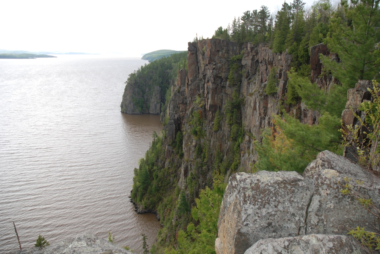
It is not just the sheer height of the cliffs that takes your breath of way. The 180°- plus panoramic view in three directions and uninterrupted sight line is unusual. You won’t see a sign on Highway 11 North urging you to “exit here” to Devil’s Rock.
and presents a short, direct walk to the precipice or a longer scenic, gentle hike. You can stop and pick the blueberries. You may have a copy of the Hardy Boys book, ‘The House on the Cliff’ by Franklin W. Dixon. The rendition of the cliff from the mystery novel series is Devil’s Rock.
The Canadian ghost writer of the popular youth series of novels, lived in nearby Haileybury. Although not born in Haileybury, Leslie McFarlane considered this small northeastern Ontario community his “hometown.” Leslie McFarlane was born on October 25, 1902, at Carleton Place, Ontario, one of four sons. His father, John McFarlane, decided to accept the position of principal at Haileybury Public School in 1910. The move was fortuitous. It was in Haileybury that he spent his formative years, and where the seeds of his writing career were planted and nurtured. At the age of 14, McFarlane entered high school. He held a series of part-time jobs during the next few years that would put him on a writing career path. At various times he delivered the Saturday Evening Post, operated the projector at the Grand Theatre n in Cobalt and set type at The Haileyburian newspaper.
In 1915 he won an I.O.D.E award for historical writing. As a student e was awarded second place in a provincial writing contest for his work entitled “Afraid“. After graduation McFarlane took a job as a reporter for the Cobalt Daily Nugget for $8/per week. A year later he moved on to the Sudbury Star where he worked for $25/week. It took him another year to realize that the demanding life of a newspaper reporter was all encompassing, he soon quit. McFarlane moved outside of Sudbury to Ramsay Lake to begin his life as a freelance writer. It was happenstance that evolved from the tragedy in his home town of Haileybury. On October 4, 1922, a great fire engulfed much of the Temiskaming region and almost obliterated Haileybury. His mother took refuge in North Bay, as did many of the residents of the town. McFarlane joined her there. McFarlane listened with great interest to the many stories of personal bravery and tragedy. The story he wrote based on the facts was submitted to the Sudbury Star. It ran as the headline story. This catapulted his writing career and he soon moved to Springfield, Massachusetts. While working again as a reporter for the Republican, he responded to an advertisement from Edward Stratemeyer, an author and publisher of children’s books.
It was then his ghost writing career would begin. The Stratemeyer Syndicate, produced the book series, the Bobbsey Twins, Tom Swift, Nancy Drew and the Hardy Boys. McFarlane earned $125 for each of the first three novels. Moving back to Haileybury provided a setting for the writer’s books. He included many symbolic references of the local area in the exploits of the young detectives Frank and Joe Hardy. It is widely accepted the Hardy Boys’ fictional community of Bayport, supposedly located somewhere between New York and Florida, was indeed Haileybury. The cliff and particularly the approach from Lake Temiskaming are prominently described in McFarlane’s writings. In the original version of ‘The House on the Cliff,” pp. 118, Devil’s Rock is described: “The cliff jutted up out of very deep water and rose to a great height…The face of the steep rock was uncompromising. There seemed to be no foothold for man or beast. It was just an unscalable , craggy wall…There were rocks at the base of the cliff. One of them, black and sharp, like an ugly tooth, jutted out from the water almost immediately at the side of the boat…”
More Devil’s Rock
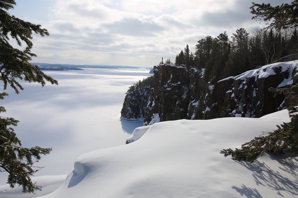 The mystique of the 150-metre , 2.2 million old fault cliff has other stories. Long before the lumber barons, explorers and Jesuits discovered Lake Temiskaming the Ojibway legend of the “rock demons” or Memequayshowak was firmly in place. As the story goes the Indians surprised the little inhabitants of the many rock crevices and the raiding party captured one of the gnomes and his knife. As the Natives withdrew, one of the remaining diminutive spirits retreated inside a deep crevice and created such fearsome noises that his captors threw back the stolen knife towards the opening of the crevice they believed was the entry to the underworld. From which evolved the local name of Devil’s Rock.
You can see these crevices from below or above. It is rumoured that Northern Ontario’s One-Horned Sasquatch has also been seen at this lofty precipice. Mining during the silver rush at nearby Cobalt has left scars of many mining tunnels chiseled into the rock walls. As you sit and study the rock formations formed by ancient upheavals and the glaciers you can see human faces etched into the rock. The Devil’s Rock is a destination for painters and photographers.
Be careful and be aware when walking near the edge and stay back a few metres. You won’t see the steam boats on the water below but try and imagine the clouds of steam and coal from the stacks. At one time more than fifty different steamboats sailed on Lake Temiskaming and its tributary rivers From the arrival of the steamer Mattawan in 1882, to the burning of the Lady Minto in 1962, a period of only 80 years, the region was transformed from a wilderness, to an extensive agricultural, mining, forestry and manufacturing district within the Tri-towns of Cobalt, Haileybury and New Liskeard. Steamboats were an important part of that transformation. There were the workhorses- large tugs like the Alexandra that towed huge booms of logs to sawmills down the take; passenger steamers-the most famous was the Meteor. But you may see rock climbers belaying down the cliff as this rocky crag provides one of the best pitches in Ontario. There are several climbing routes that have been described in many journals, technical single and multi pitch crack routes rising from the water’s edge. Take your binoculars, Peregrine falcons have returned to area and are frequent visitors as you gaze across the lake or southwards towards the narrows of Ottawa River, near Ville Marie, Quebec. At sunset, on a starry night, during a heat lightning storm or a magical experience with Aurora Borealis…pick a time and you will feel the connection with this rocky pinnacle. You will not be disappointed.
Access
There are two accesses to consider. It is the shorter route that is the gem of information. The shorter walk of less than 30 minutes (one way) is approximately 2 km in length (linear route) from an unsigned, small parking area on secondary Highway 567 (It will be on the left or east side of the secondary road). Look for the unmarked trailhead atWGS 84, Zone 17 T E 605620 N 5250762 or N 47 24.106 W 79 36.012 . Check your map. (If you are using the paper map check the map datum on the paper topographical map and change your GPS settings accordingly) 17 T 606478 525047017 T 606478 5250470. This is your starting point.
See the maps. It is approximately 4.7 km from King St./Highway 11-B between Cobalt and Haileybury. It is unmarked and parking is limited (but there seldom is another competing car). The walk, and it is a walk, not a hike, is flat and the shorter route makes for a better access for snowshoeing in the winter or a walk at dusk. The trail leads you to the bginnng of the cliff area, where the trail meanders along the edge. The destination here is approximately Zone 17 T E 606385 5250730 or N 47 24.081 W 79 35.404
Why approximately? There is a series of meandering trails at the cliff’s edge which zig and zag to various viewing areas in both directions N to S. When you first see the water you will want to mark your location and be aware of where your return trail is located. It is easy to get turned around because of the network of trails meandering through the blueberry bushes and stunted vegetation. The longer route of approximately 3 km (or less than one hour-one way) starts at the municipally operated Bucke Park (the road is not so accessible in winter) has better parking, signage and camping. You will see the turn off to Bucke Park on Highway 567 (Bucke Park 705-672-2611). The walk becomes more of a gentle hike as you ascend the contours to the precipice. Again, be careful when walking near the edge. There is access to the cliffs, to consider, from the marinas in New Liskeard or Haileybury; that gives a different perspective of the cliffs, for sure. While in the area consider the museum in Haileybury for more information on Leslie McFarlane and the Hardy Boys. There are the museums in Cobalt and the driving tour of its mining heritage to consider.
For KMZ, GPX and Maps Devil’s Rock
Google Maps This takes you to the trailhead on Highway 567, just 5 km SW of North Cobalt. Click on the more info pop-up and there also the Satellite View (you can zoom in and out + (in) and – (out); you have to zoom out to use the terrain map.