
What a Rush – Eau Claire Gorge, Rutherglen (North Bay-Mattawa)
by Back Roads Bill
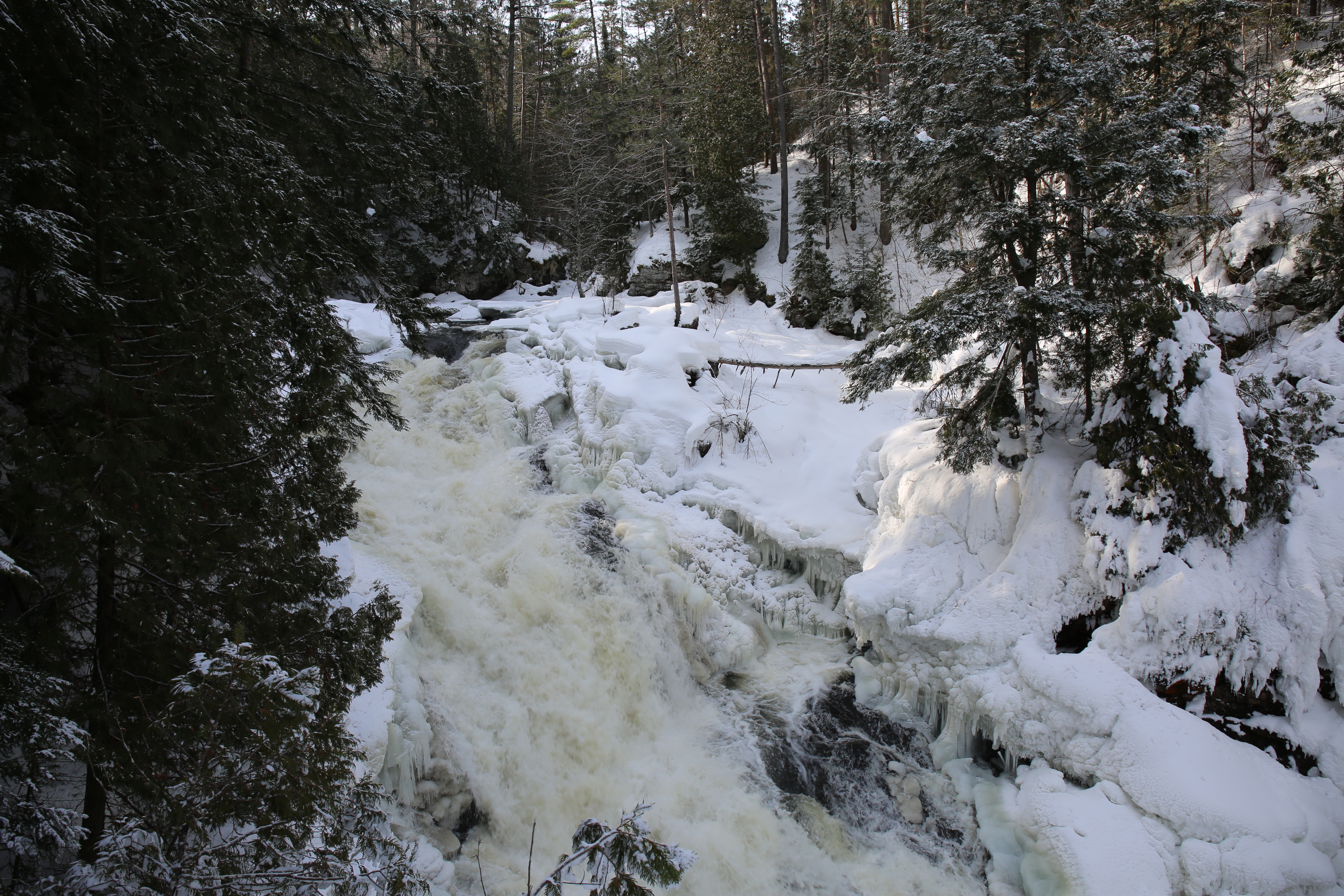
Throughout the year the gorge initiates an array of feelings and emotions. It is a walking place, very moving. It is oneof those waterfalls where you hear the tumbling water before you see it. There is anticipation and you will not be disappointed when you peer over the edge!
 Winter brings a snowshoeing trek that allows you to see moving water through a winter wonderland. Fall brings the colours and the spring freshet shows the power of the cascading volume of water. A summer’s day hike allows for a cool stroll through a mixed forest and a red pine ecosystem. You will not want to miss the spring freshet.
It always amazes me that more people “haven’t been to” the picturesque Eau Claire Gorge. It is just off Highway 17 and is a Northeastern Ontario treasure.
This scenic gem of the Bonfield-Mattawa region is very accessible and offers an easy walking tour, with options, for a wide range of demographics. It is not often you can locate yourself in the “middle of a water fall.” This a location often missed by passersby. It will make taking your camera more worthwhile! You will journey to the small community of Eau Claire. The original Eau Claire, named after the clear water of the Amable du Fond River was at the twin bridges you will drive over on Highway 630. Lumberman William Mackey established a community there starting in the 1870s while he was taking out squared timber.
There is another legacy attached to this area. Francophone settlement rapidly increased in the Mattawa area with the arrival of the Canadian Pacific Railway (CPR) in 1881. During construction of the rail line, the local economy benefitted from the presence of thousands of French-Canadian workers, some of whom were accompanied by their families. Some came to the area while working on the construction of the railway and decided to stay, while others arrived by train with the express intention of obtaining and settling on a piece of land. Once the railway was operational, the local lumber industry expanded and communities like Eau Claire, Bonfield and Mattawa prospered as supply and transportation centres. The drive to the gorge and through the back roads reflects the patchwork quilt of remaining farmsteads. Pioneers who stayed and eked out an existence on the Canadian Shield. These settlers brought with them their unique culture and heritage, and left a lasting francophone legacy in this area of Northern Ontario.
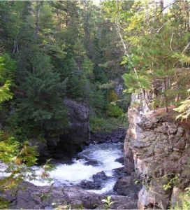 The fast moving Amable du Fond River, originating from the dome of the center of Algonquin Provincial Park, travels 84 km and drops 263 metres over its length, ending at the Mattawa River in nearby Samuel de Champlain Park. The river flows through a tight gorge and then suddenly cascades between the steep rock walls of the Canadian Shield. The river itself is named after an Indian Chief from the Algonquins near Mattawa. The trail along the river is an important link with the natural and human history of this site.
A fault ridge that extends across the conservation area dominates the gorge itself. This fault in the earth’s crust resulted millions of years ago when the bedrock split and dropped on one side. Where the river tumbles over this fault, glaciation from the most recent ice age and constant erosion, has carved out the gorge. The main falls is a tall cascade about 15 m in height and 10 m in width. It pours into a deep, narrow forested gorge that is not lined with a safety fence. The gorge walls are high and steep, including a huge rock gate on the opposite side of the river
The abundance of red and white pine attracted many loggers to the Mattawa valley in the mid 1800’s when the square timber industry was in full force. When the area was logged, timber was cut during the winter and piled on the ice to await the spring melt when lumbermen would then guide the logs downstream. During this time the loggers established camps along the river and a shanty was built for the lumbermen close to the slide. The earth trench that housed the log slide remain as a visual reminder of the past. The “long slide” as it was called bypasses the brink of the gorge. It is the application of past technologies and of the challenges the “loggers” had with moving square timbers around obstacles like the gorge. Steel sleigh runners reinforced the curves of the slide, which measured 370 meters (1233 feet), in length. Its opening measured 3.9 meters (13 feet) wide enough to allow four to five logs to pass at one time. A dam was built to hold back the water before it entered the gorge, this raised the level of the water in order to divert the logs. The slide was first used to transport logs downstream to the Mackey mill situated near those two, one lane bridges you would have driven over on the way to the gorge on Highway 630. Later, lumber baron J.R. Booth used the slide for the “log drive” down the Mattawa River to the Ottawa River. The slide was dismantled for its timber in the 1930’s. (See the GPS coordinates in the Access section).
There’s More
There’s also a reconstructed cabin on the trail that includes the story of one mysterious “squatter.” He lived at this isolated location in the early 1900’s and his background suggested by early pioneers was connected to “fleeing from a murder” somewhere in his New England past. Adjacent to the cabin you can surmise where his meager garden once was.
Watch for the remaining evidence and traces of the 1954 storm, Hurricane Hazel. These are best viewed on the trunks and are indications of the high water marks. It is as if someone drew a straight line across the trunks. Watch for the “super size” remnant old growth white pine; give it a hug. Charred stumps indicate past forest fires. If it’s a windy day stop amongst those majestic red pine trees, close your eyes, the sound is both distinctive and unforgettable, “…the wind whispering in the pines…”
If you like trees the walk to the gorge takes you through a natural maturing forest. The Eau Claire property has a forest cover that is characteristic of the entire Mattawa watershed. Although it is been both logged approximately more than 120 years ago and burnt over (100+ years ago), the area has returned to a mature stage in its evolution providing a well mixed variety of species. The eldest species in the area are Red Pine (Pinus resinosa) and White Pine (Pinus strobus). You will walk through the large red pine stand by taking the circle trail. There are a couple of remnant old growth white pine trees close to the trail that parallels the river. The eldest hardwood is the Large Tooth Poplar (Populus grandidentata), some of which are up to 100 years old.
A trip to the gorge means a link with the past and the era of the white pine loggers. Try to envision those logs shooting through the logs slide while sensing the vigorous labour of those river drivers. Hum the lyrics of the songs popularized by the Canadian, logging heritage singers, Wakami Wailers. It also means a connection with nature and those natural processes that carved out the beauty of a site we can appreciate as we peer over the edge of the gorge. Bring your camera. Enjoy the walk.
While you are on Highway 630, take the “Sunday” drive to Kioshkokwi Lake and visit the most northerly access point to Algonquin Provincial Park and find out why Kiosk became a ghost town. That’s another Back roads Bill story. Take the time; leave the highway and the take the back roads of Northeastern Ontario.
Search, See, Learn and Stay Awhile at www.visitmattawa.travel for all destination services.
For KMZ, GPS and Maps Eau Claire Gorge
Google MapsClick on the more info pop-up and there also the Satellite View (you can zoom in and out + (in) and – (out); you have to zoom out to use the terrain map. This takes you to the trailhead from Hwy. 530 (Kiosk and Algonquin Provincial Park) just south of Highway 17 East between Rutherglen and Mattawa.