
‘The Tower and the Road’ – Temagami and Lake Temagami
Lasting Legacy
by Back Roads Bill
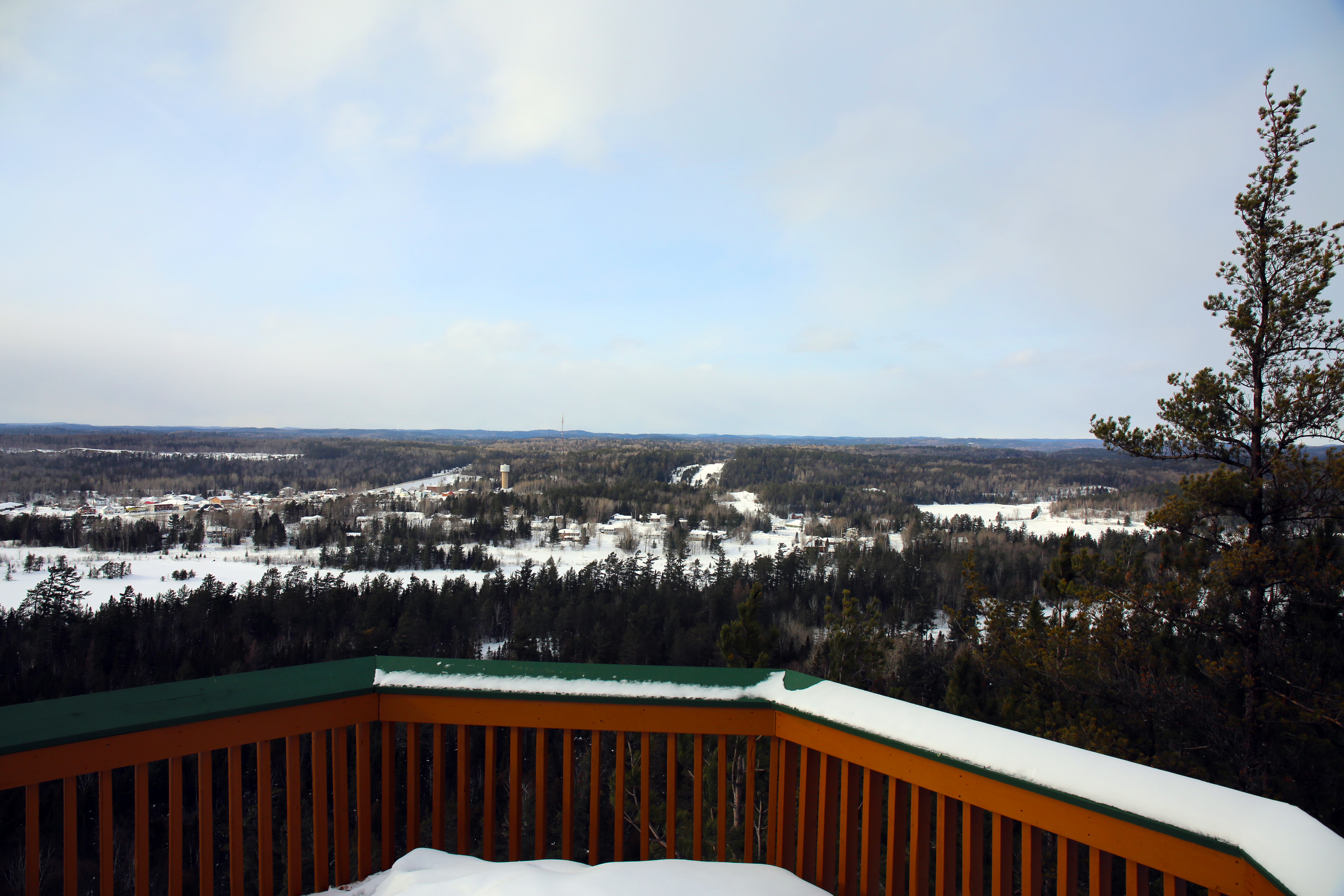 You have just climbed the Temagami Fire Tower and hiked the White Bear Forest. What a view, one of the many you will discover in Northeastern Ontario. And those white pine trees, majestic. After all it is Grey Owl country!
There are many forest access or logging roads in Northern Ontario. One road in particular reflects a long standing heritage. It is a few kilometres north of the town on Highway 11 and worth the detour.
A heritage important to many, one individual is a well-known and early environmentalist then known as a conservationist.
In more contemporary times the road truly represents the natural and cultural values of one icon of stakeholders wanting to utilize and protect the wilderness.
Impostor has Love for Nature
Sunday, September 18, 1989, marked the centennial celebration of the birth of Archibald Stansfeld Belaney. That name is seldom recognized. Although he only lived for one-half of these 100 years, Grey Owl ‑ as he is better known, remains with us. That same day in 1989 also marks the Wakimika Creek bridge environmental protest by Natives and naturalists. Both are important dates for the Temagami wilderness.
Taking a ride on the Red Squirrel Road, just north Temagami and west of Highway 11, will not only take you to a great picnic or camping/canoeing/hiking location but will take you back to an example of contemporary environmentalism. You will understand the motivations of all the stakeholders. It will also allow you to get to know how and why the Temagami area impacted a conservationist.
Grey Owl had great passion for the wilderness. He was also a great impostor. He came out of the Temagami wilderness as a 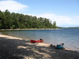 trapper/guide/forest ranger, to win international fame, many years later, as the author of some of the best nature books ever written. He used his fame in the early 1930’s to become a champion for the preservation and protection of the Canadian wilderness. His stories within Tales of an Empty Cabin, published in 1936 and a 1937 film on his adventures, promoted the values of canoe‑tripping.
Grey Owl created the persona of a “Noble Indian”, who cared about the Native culture and traditions and link with the land. He told the world, through four books and extensive lectures, about his Native heritage. Within hours of his death, April 13, 1938, the mask of secrecy was removed and his English roots as a full‑blooded, educated, white man were finally uncovered. He was an eccentric, an unusual breed, who had adopted beliefs and dress to meet his goals. A reporter for the North Bay Nugget, Britt Jessup, had actually written a newspaper story several years prior to Grey Owl’s death, but the revealing story was never published until the day after he died, out of respect for his accomplishments.
Today, the Temagami wilderness remains controversial. If you examine Grey Owl’s legacy you see the threads that eventually lead to the infamous standoff at the Red Squirrel Road. Driving this road to a destination will help in understanding how passion and protest helped preserve this wilderness.
But Grey Owl leaves behind more than a myth. He leaves us his writings, the evidence that makes the disputed area so important to the Teme‑augama Anishnabai (Bear Island Indian Band), the lumber industry, tourist operators, permanent and seasonal residents.
The Players
A look back at the turn of the century, will help in understanding the evolution of the participants mentioned in Grey Owl’s comments about the Temagami area.
The long‑established Natives started to trade in furs at the Hudson Bay trading outpost, established in 1834, to stem the tide of independent traders that were threatening the company’s monopoly. The Bear Island trading post was established in 1875/76, closer to the center of Lake Temagami.
To the south, the logging operations of J.R. Booth and the Gillies Brothers had started cutting pulp in the area of the Sturgeon River valley and to the east near Lake Temiskaming. On the east, William Milne and Sons Lumber Company of Trout Mills (Trout Lake ‑ North Bay) would soon benefit from cutting along the proposed rail line of the Temiskaming and Northern Ontario Railway ‑ chartered by the provincial government in 1902.
The recreation potential in the early 1900’s was recognized not only by railway promoters, but in a provincial government publication entitled, Northern Districts, it states, “from a picturesque point, the finest lake in America,” and “it appears to have the makings of an ideal summer resort in it,” (Hodgins). It was an accurate prediction of the future. The development of many children and adult camps, along with resorts, soon provided another economic component for the Temagami area.
Copper and nickel developments in the Sudbury mining basin and the silver boom from 1901 ‑ 1911 in nearby Cobalt, resulted in the area being extensively surveyed and prospected.
When a seventeen year old Archie Belaney arrived in 1907, the roots of all the above groups were at different stages of development, with an evolving impact that did not come to a head until today (1980’s). The natural resources of the Temagami area were being utilized, but without conflict.
The Past Evolves
The Indian heritage that Grey Owl speaks about in two books: The Men of the Last Frontier (1931) and Tales of an Empty Cabin (1936), evolved from a 6,000 year existence in the Temagami area. The N’Daki Menan, the aboriginal homeland of the Temagami Indians (Deep Water People), have wandered throughout the area by using the nastawgan ‑ a system of trails (portages) and waterways (canoe routes).
The Forest Reserves Act of 1898, an attempt at multiple-use management, identified the potential for the area. In 1901, planners set aside the Temagami Forest Reserve (6,000 square miles), through which the government envisioned a perpetual source of timber and public revenue. At the time, this was thought to be the largest reserve of red pine in cental Canada. What was supposed to be an area of pine management, became an area of cutting leases.
In the year of Archie’s arrival, survey crews were busy laying out a townsite at the northeast arm of the lake, and leases for summer resort purposes were being approved by the government. Temagami Lodge, opposite Bear Island, was being constructed to accommodate rich, and predominantly American tourists seeking a wilderness experience. This enterprise was to give Indians employment, while making their life more comfortable.
Archie Belaney had come here to fulfill a dream of becoming an Indian, and what he saw, was a threat to his romantic dreams of living with them in isolation. He adopted the Indian way of life, married an Indian girl, Angele Eguana, and became assimilated in their culture. But their hunting and fishing grounds were not protected by law, what he saw was an eventual loosening of the cohesiveness of the traditional native ways. It was these developments that drove him away from the area to Biscotasing (southeast of Chapleau).
What He Says
In Tales of an Empty Cabin, he prophesizes about how the wilderness should be managed. “The Wilderness should now no longer be considered as a playground for vandals, or a rich treasure trove to be ruthlessly exploited for the personal gain of the few ‑ to be grabbed off by whoever happens to get there first.”
Within the same book under an essay entitled: Tolerance, Grey Owl addresses forest management. “The function of the forest is not exclusively that of providing lumber, though judicious and properly controlled garnering of a reasonable forest crop is essential to industry. There are many reasons, aesthetic, economic, and patriotic for the perpetuation of large tracts of unspoiled original timber ‑ exclusive of re‑forestation. This last scheme should be carried on intensively, and commercial concerns should be obliged (and many of them do, to their credit) to plant six or a dozen trees for every one they cut, thus putting in their own crop, and so be made to keep their acquisitive eyes off some of Canada’s remaining beauty spots, which will be irretrievably ruined if commerce has its way with them. There is plenty for all purposes, if patronage does not outdo honesty.”
In Men of the Last Frontier, he again looks at what might happen to the wilderness and the interaction of Natives and other land users. “In the darkness from over all the length and breadth of the wild lands there came a murmur, and the air was filled with the sound of a mighty restling (sic) as of an innumerable multitude in motion. And the dark masses of the forest seemed to roll up behind those who had already gone before, to recede like the outgoing waves of an ebbing tide, as though, defeated at last, they retired before the juggernaut that was now upon them, fleeing in the face of the doom that had threatened them now for three hundred years.
And with them went all of the Wild that had life, following the last fading line of the Vanishing Frontier, Northward, Northward, ever Northward, back into the days that are long forgotten, slipping away over the hills into the purple distance, beyond the Land of Shadows, into the sunset.”
In September 18, 1989, Temagami became the focus of environmental activism. In response to plans to log Temagami’s old-growth red and white pine forests, environmentalists, First Nations, and other concerned citizens staged one of the largest peaceful blockades in Canadian history. The group included, then Ontario New Democratic Party leader, Bob Rae, a year later he became the Premier of the province. The well organized campaign and public response turned the table. More than 340 people were arrested blockading the logging road construction (there were actually three , ongoing protests ong at Sharp Rock Inlet, Sandy Inlet and the Wakimika Creek Bridge). The 84 days of passion and protests worked, the government responded, stopped the logging and initiated a long standing 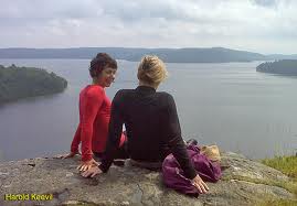 comprehensive land use planning program.
Like Thoreau, Leopold and Sukuki the writings of Wa‑Sha‑Quon‑Asin (Grey Owl), blood‑brother of the Ojibway, naturalist and prolific author, continue to arouse interest in conservation and in our ecological heritage. Research indicates the Temagami area had a lasting impact on his writings.
What Grey Owl tells us, are the truths of why this area has a diverse composition of natural resources important to many people, in many different ways. It is a story with a beginning, but without an end, the Natives continue to negotiate for the land, that will satisfy all who cherish and use the Temagami area. When you visit you know it remains a special area. You will return.
To view the White Bear Forest Trailhead in Google Maps White Bear Forest
To view the Red Squirrel Road access in Google Maps Red Squirrel Road
For Maps, GPD, GPX and KMZ Download
For more to the story please visit Northern Ontario Travel
Access
The Red Squirrel Road will also lead you to one of the easiest access points to the world famous Temagami-Lady Evelyn wilderness area. The area’s water trails are known as Nastawagan and is a canoe tripping Mecca.
The Red Squirrel Road (RSR) is approximately 9.5 km north of Temagami, the turn off is on the west side of Highway 11. For our destination it is 29 km and the road shortly thereafter is restricted to any additional westward travel. The RSR travels NW for approximately 8 km and then runs mostly east-west in orientation. The road will lead you to Ferguson Bay a great place for a picnic, overnight stay or the place to start you paddle to Lake Obabika, see the Story ‘Become One with the Land.’ You could visit a magnificent log structure called the Chateau at nearby Camp Wanapitei and hike a trail to Mount Ferguson which gives you a panoramic view of the area.
Driving at approximately 25-45 km/hour it will take you 40 to 50 minutes to reach the destination. But there are lots of stops on the way. This can be a day trip or the launch of a canoe trip. It is a gravel road and well travelled.
You will notice small signs marking the km intervals along the RSR.
At 4.5 km you will see the north end of Net Lake on your left or SW side of the road.
At approximately 5.5 km there is a one lane bridge and a set of rapids and a portage to walk on the right side or north side of the road. This leads to Thieving Bear Lake. A good place to stretch your legs and walk the short portage.
At approximately 7 km you will see Thieving Bear Lake again and a camp site.
Between the 8-9 km mark on the road there is turn off to the south, DO NOT turn.
Carrying on the RSR at the 10 km mark you will cross Snare Creek.
At about the 14 km point there is a portage to the north to Lundy Lake and a camp site on the south side of the road.
At the 15.5 km mark there is access to the south to Tyndall Lake. At about the 17 km mark there is more water (small lakes) along the south side of the road.
At about the 19.5 km mark there is a single lane bridge. To the north and south of the bridge is the Anima Nipissing River. Going north you would access Anima Nipissing Lake that has a true floating bog, pictographs, a mine shaft and a “strange” rock with volcanic intrusions (that’s another story). Anima Nipissing is the headwater of Lake Nipissing. You get a good idea of the concept of what a watershed is. From Anima Nipissing the volume of water flows to Lake Temagami and then south through Red Cedar Lake down the Temagami River (a good canoe route) to the Sturgeon River and eventually Lake Nipissing!
At this point the river, flowing south, parallels the road until it reaches Red Squirrel Lake.
(Between the 20 to 21 km mark, on the south side of the road look for the huge glacial erratic –boulder at coordinates WGS 84 17 T E 576466 N 5225182 or N47° 10’ 32.5” W79° 59’ 27.2” It is worth a stop to walk the few metres to see this true evidence of the last glacier.)
To the south of the bridge the river flows to Red Squirrel Lake. The road from here parallels the river until it reaches a popular Crown Land camping area at approximately the 22 km mark on the road. Some Crown Land camping locations, throughout the province, have caused some access problems to many wilderness locations. Campers for the most part are respectful and move their trailers. You will see trailers at this access.
Between the 23 km to 25 km mark you will see the upper, NW reaches of Red Squirrel Lake.
At the 27 km mark you will veer left or WSW. The right fork has a sign for Eagle Lake and travel is also restricted.
At the 29 km mark you will arrive at the south turn marked by a Camp Wanapetei sign. There is a old reforestation sign on the north side of the road marking the jack pine plantation of 1966-1971. These trees are maturing.
As you turn south you quickly come (50 m) to a “T” intersection. DO NOT turn left or SE, this is the access to Camp Wanapitei.
You are within the sandy soil of the jack pine stand. The road is good, proceed until you come to another turn where the road will turn sharply to the SW. You can park here at the first parking area. You are close to your destination (N47° 10’ 02.9” W80° 04’ 46.0” or WGS 84 17 T E 569766 N 5224186.
Within the sandy soil there are some ruts, if you are going to drive on to the second parking area it is worthwhile to take a look. Most times it is passable, take it slow and keep you wheels on the crowns of the road. If you nudge or “bottom out” it is sand. It is a five minute walk from the first parking area to the second parking area.
Anyway you will quickly walk or drive to the second parking area. From here it is a five minute walk to to the beach. There is one damp area on this trail. When you arrive on a sunny, summer day you will arrive at a magnificent sand beach. You won’t be disappointed.
This is a great access point to canoe northwards towards Diamond Lake or westwards ending up in Obabika Lake (another old growth story and trail system).
You can relax all day or setup camp. Whatever time you have walk SE or left facing Ferguson Bay until you reach Camp Wanapitei. Check in and ask if you can see the “Chateau” and then directions to the Ferguson Bay lookout. You have to go over the bridge over the Red Squirrel River and follow the bridge to the trail that leads to the lookout.
It is one of the oldest canoe tripping camps on Lake Temagami, Camp Wanapitei. It is also the former residence of the colorful “rebel” priest, Father Charles Paradis. He was an entrepreneur and established several colonization schemes in northeastern Ontario including an orphanage and farm here on this site. The site was abandoned in 1924
Camp Wanapitei dates backThe name Wanapitei (pronounced wawna – puh – TAY) comes from the Anishnabai name Wanapiteiping, which means “oblong body of water, full to overflowing.
Previously an semi-agricultural settlement founded by Father Charles Paradis in 1891, Wanapitei was established as a summer camp in 1931 under the direction of Ed Archibald. The Chateau structure is worth a visit. When the Wanapitei Chateau opened its doors in the spring of 1934, it was the last stop on a 50-kilometre steamboat ride from the village of Temagami. The massive two-storey log structure is designaed as an Ontario Heritage Building. It had been hewed out of the forest the preceding winter by the Maki family, fresh from Finland, and was owned by Canada’s WWI Director of Recreation and Sport for the troops in France and Olympic pole-vaulting bronze medallist, Ed Archibald. In 1956, he sold the camp to Stan and Laura Belle Hodgins. The Hodgins family, including Bruce Hodgins developed a unique, camp which stressed canoe tripping and wilderness skills for boys and girls. The tradition carries on.
The early conservationist and the “great impostor” Grey Owl would have stopped here at this beach or portaged along the Red Squirrel River.
From the foot bridge adjacent to the “Chateau” it is approximately a 3.0 km walk (one way) to the Ferguson Bay lookout. You get a 270° panoramic view of Ferguson Bay and beyond. It is a great vantage point to look back at your picnic or camp site.