
Nature Trail and Legend – Dokis – Lake Nipissing West – Hwy. 64
Cultural Trails Tell Stories: Dokis Embraces More Tourism
by Back Roads Bill
Trails are integral to the landscape and develop meaningful connections between people and nature. No more so than to our First Peoples and their relationship with the land.
Besides evidence of where people lived and travelled, trails offer clues as to the cultural values and practices of the people who used them and use them. Dokis First Nation on the far west side of Lake Nipissing at what is called the “Little” French River is a good example of a burgeoning tourism “gem.”
It started a number of years ago, the Dokis First Nation, with members of more than one thousand, including 300-plus residents, overwhelmingly voted to not commercialize its fishing and forestry resources. There is no commercial netting of fish and forestry practices are restricted to pulp and firewood and stand improvement.
 Clayton Dokis has been working on the trails for more than eight years and is the community’s eco-tourism project manager. He is an interpretative guide and knows a great deal about medicinal plants. A group tour with Clayton is recommended. (Pers. Comm. “one of the best encountered; Back Roads Bill will look forward to the next visit.”)
The community has always been at the center of one of Ontario’s early tourism destinations that saw a flood of Americans purchase islands for camps and cottages (no one seems to know what word to apply). “The Little French River’s scenery is rugged with white and red pine stands along with exposed, glaciated rock,” he said. “Now there is a new era of tourism economic development including interpretive land and water trails.”
“The First Nation lands (39,000 acres or 15,782 hectares) are composed of two large islands which are nestled within the flows of the historic French River,” explained Clayton. “The main settlement or community is located on the northern island called “Okikendawt Island” (meaning island of the buckets/pails). The name is derived from several bucket formations in the rock due to centuries of water flows to these areas. The buckets were often utilized for tobacco offerings for safe passage through the territory.” This scenic backdrop, with the Georgian Bay feel to it, is the setting for trail development.
The Trails and a Legend
There are three trails, guided or self-guided, that highlight the initial stage of tourism development.
The 2.6 kilometre (km), (one way) Chaudiere Trail starts at Charlie’s Bay (community marina) and connects the upper and lower  French River. It features the large, green steel gates built in 1909 during the logging era of J.R. Booth; it was also important to the ill-fated Georgian Bay Ship Canal which would have joined Georgian Bay with the Ottawa and St. Lawrence Rivers.
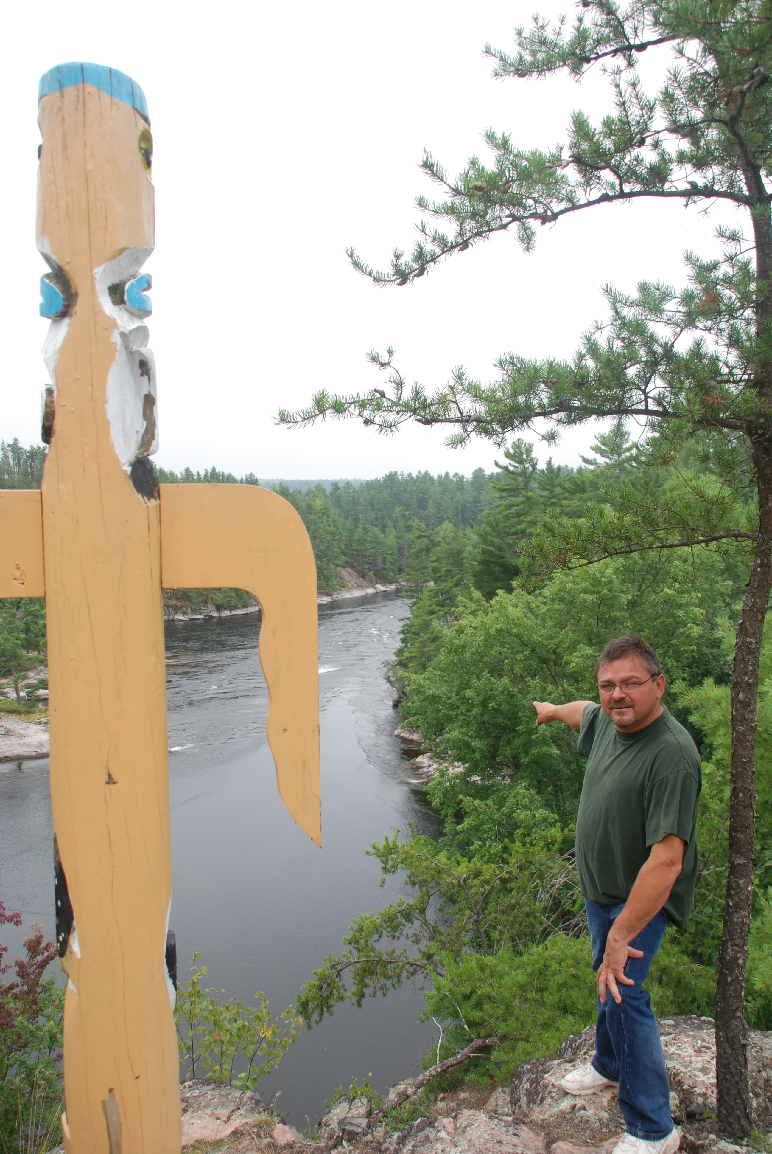
Along the way is the Cradle Rapids. It is not only a wonderful vantage point it has a legend embedded in the rocks. Clayton recalls the oral tradition of the legend. “During the Indian wars with the Iroquois, in a panic, a baby was left in a cradle as our people fled. The baby turned to stone to avoid being taken by the captors and was immortalized forever; you can see the cradle leaning against another rock on the south-east side of the river at the narrowest, upstream point of the rapids.”
The 2.8 km Tikibi Trail accessed from the Band’s office features a variety of medicinal and edible plants and mushrooms. The trail passes through a rocky coniferous forest accompanied by a lake and ponds; it connects with the Chaudiere Trail.
The 10 km (one way) Papase Trail is easy to moderate in difficulty. According to Clayton it is a “backwoods trail away from any community or human intervention giving that personal peace of quiet feeling.” The trail passes along the Lower French River; there are two campsites and several rest areas. You can arrange to be picked up along the way. Current development include the extension of this trail to the famous Five Finger Rapids; (YouTube: Fiver Fingers Rapids French River) its beauty and magnificent, unspoiled scenery will be worth the hike.
There is also a kayak/canoe trip; this will include downstream travel to the Free Flowing Channel, the only outflow of Lake Nipissing that is not dammed; a wonderful place for tubing. It is a looped canoe/kayak route back to Dokis, upstream from Five Fingers through another French River channel. (The author has tubed, canoed and kayaked this route and it makes for an enjoyable two-night, three day trip; with only three portages, starting and ending at the marina. Mark this on your list, particularly for all those consumers with the mid-sized to large sea kayaks on the top of their cars looking for a camping adventure; the portages are relatively short, flat and well-trodden from centuries of travel.)
Clayton said the community realizes there is an additional need for more four-season accommodation and a trailer park. “The completion of the new 10 megawatt generating station on the upper spillway will allow for new tourism infrastructure.”
A Destination
Make the Dokis trails a destination and to launch your water craft. Travel west from North Bay, through Sturgeon Falls on Highway 17 to Verner, turn south on Highway 64 (stop in Verner to read the historic plaque – Reverend Charles Paradis – “the rebel priest.”). Lavigne is 13 km from Verner on the west arm of Lake Nipissing; an expansive view to the east. Journey fifteen more kilometres you could stop at the Loudon Peatland Trail, one of the best snowshoeing trails in the area, with a lookout tower. Dokis Reserve Road is 1.6 km past North Monetville. It is another 28 km, east to Dokis on a good, all-weather gravel road (there was no connecting road prior to 1960 and the community crossed the lake to Sturgeon Falls during all four seasons.) The Cradle Rapids viewing location is found at N46° 06.985’ W80° 02.466’ or WGS 84 17 T E574094 N5107429 at the lower Chaudiere Rapids. The upper rapids is the humankind made channel and new generating station accessed by the Keso Bay Rd., worth a view from the single lane bridges. For more information contact Clayton Dokis at clayton.d@dokisfirstnation.com or www.dokisfirstnation.com .
The Dokis trails hold a lot of history of a people who have lived with and used these land and water trails for many centuries; they want to share their natural heritage; take a hike or a paddle on these “diamonds in the rough,” (yikes, and snowshoes soon enough).
.GDB File