Erratic Behaviour – Ice Age Reminders
Glacial Droppings – Movement
by Back Roads Bill
Humans sometimes exhibit erratic behaviour but even rocks can do so.
Boulders of a particular rock type which may be many tonnes in weight may be found sitting on a different type of bedrock; sometimes they are perched prominently in open areas. For the most part they tend to be rounded. The surface is often fine grained indicating grooves and scratches, remnants of the movement of the ice sheets and the constant scoring by neighbouring boulders. After the ice melted the boulders remained distributed in a random way.
Most parts of Northern Ontario have been glaciated that is, ice sheets once enveloped the landscape. Glacial striae (you can see these scratch patterns on the bedrock) and glacially oriented features, such as drumlins and eskers, indicate that the general direction of ice movement was towards the southwest. So as a result most areas have erratic boulders.
Dr. Eric Mattson was contacted at Nipissing University. His speciality is snow and ice hydrology; glaciology and glacial geomorphology. He provided an “erratic” primer.
“The term “erratic” is commonly used to refer to rocks that have been transported by glacier-ice to locations with differing lithographic character,” said Dr. Mattson. “They are one of a series of indicators which mark the path (direction) of past glacier movement. An examination of their mineralogical character leads to the identification of their parent bedrock sources, allowing for confirmation of the ice flow route.”
He said, “The size and shape of erratics vary tremendously. They can range in size from small pebbles to large boulders as big as a house and their shape can vary from being very angular to round. These characteristics are a function of the original size and shape of the rock when it was entrained into the glacier system, whether it was transported on top, within or underneath the glacier, its mineralogical character, whether melt-water was involved and the distance which it travelled.”
He explained the most recent ice age as it applies to Northern Ontario. “The Wisconsin Glacial Episode was the most recent major advance of the North American glacier complex of which the Laurentide ice sheet covered Northern Ontario. The maximum ice extent occurred approximately 25,000–21,000 years ago. This advance erased all the previous Illinoian glacial topography that extended over this area hence, all erratics found here belong to the Wisconsin Glaciation.”
Dr. Mattson identified the Okotoks Erratic found in the foothills of Alberta as one of the largest in Canada. It is known as “The Big Rock.” The Okotoks Erratic is the largest known rock in the Foothills Erratics Train, a group of rocks that were carried by ice along the mountain front and let down as the glacier melted more than 10,000 years ago. These erratics lie in a narrow band extending from Jasper National Park to northern Montana. The Okotoks Erratic weighs an estimated 16,500 tonnes. It measures about 9 metres high, 41 metres long and 18 metres wide. The rock has broken into pieces, but is still a large landmark on the flat prairie. What about Northern Ontario?
Blueberry Boulders – Ignace
 Just north of Sandbar Lake Provincial Park, a dozen kilometres north of Ignace in northwest Ontario the landscape is dominated by large room-size boulders that rival the Okotoks erratic. Visitors walking among these behemoths cannot but be overwhelmed by them.
Dennis Smyk, editor of the local newspaper, ‘The Driftwood,’ explained the discovery. “The Ignace boulder field came to light following forestry operations. In 2004, the boulders stood out above the cutover. Five years later, rapidly growing jack pine began to hide them from nearby access roads. People interested in promotion of the area engaged Sandbar Ontario Rangers to undertake brushing to open up the areas around the boulders and create trails between them.
He explained what a geomorphologist told the locals about their origin. “These boulders were angular chunks of fractured granite that were removed from the bedrock surface by advancing ice about 10, 000 years ago. This was usually accomplished by freeze-and-thaw processes in which water (often under very high pressure at the base of the ice) makes its way into fractures, freezes, expands as ice and wedges the fractured blocks apart. The blocks were eventually plucked out and became entrained (frozen) in the ice.
Their size and uniformity (i.e. all granite) suggests that they were derived locally (likely within 5 km) and deposited fairly close to where they originated in bedrock. After the ice retreated, meltwater would flow between the boulders and winnow out all but the largest boulders. The finer material would be deposited farther downstream. The transport in ice and contact with meltwater has smoothed some of the sharp, angular edges that these blocks would have had initially.”
The size of these boulders and their proximity to the Trans Canada Highway means that there is a great deal of interest by boulderers, aficionados of the sport of bouldering, a style of rock climbing undertaken without a rope and normally limited to very short climbs so that a fall will not result in serious injury. It is typically practiced on large boulders or artificial man-made boulders. “The Ignace Boulder Field has been described as “the best bouldering in Canada between the Niagara Glen and the Rockies!” He said, “Visitors will enjoy the experience of seeing the boulders – or climbing them – and can top up their visit by feasting on the namesake blueberries. Keep an eye open for roadside raspberries, too.” You can find these 15 km north of Ignace on Highway 599 (Savant Lake), pass the Park entrance and drive 4.3 km and turn at WGS 84 15 U E607201 N5484213 or N49° 30.064’ W91° 31.166’ (note you are on the 49th N parallel of latitude); drive 0.7 km NNW and then turn WSW and drive less than 0.5 km, the boulders are in sight (north side) scattered amongst the jack pine. These are enormous. You can see the extensive field as large white dots on Google Earth.
More Erratic Boulders
A number of beauties that are closer by.
A very large one is located 10 km north of Windy Lake Provincial Park (north of Sudbury) on Highway 144, just before Cartier on the east side of the highway; you can’t miss it! (N46° 40.671’ W81° 32.592’ or WGS 84 17 T E458456 N5169509).
Another is along the Red Squirrel Road accessed just north of Temagami a wonderful back roads, 29 km drive to the sandy beach on Ferguson Bay on Lake Temagami. Between the 20 to 21 km mark, on the south side of the road look for the huge glacial erratic – at coordinates WGS 84 17 T E576466 N5225182 or N47° 10.541’ W79° 59.453’. It is worth a stop to walk the few metres to see this true evidence of the last glacier.
See the bear icon on the large erratic found on the shore Lake  Temiskaming NE of Dawson Point near New Liskeard (Temiskaming Shores); (WGS 84 17 T E 606013 N 5259941 or N47° 29.056’ W79° 35.567’). Also in the immediate area a large erratic on the intermediate, “blue” trail at the Temiskaming Nordic Ski Club.
Then there are the “Stonhenge of the North” erratics located east of Virginiatown (east of Kirkland Lake) off of Highway near the shores of Larder Lake. This is a spiritual location where the erratics are lined up in a north to south direction and linked to a constellation. Journey east of 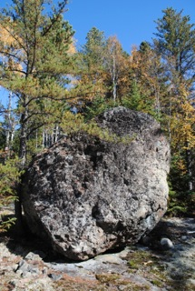 Kirkland Lake on Highway 66, through to Larder Lake. From the junction of Highway 624 and 66, at the community’s fish monument, travel eastwards on Highway 66 for six km. Watch for an unmarked road (N48º 06’ 56.4” W79º 39’ 00.7” or WGS 84 17 U E 600464 N 5330036) on the right or south side just before the Bob Lake/Tournene roadside picnic area. Travel this side road; there is one hill, for 1.5 km. When you come to the fork veer left or SSE. If you go right or SW you would end up at Pearl Beach. Within 200 m you will park amongst the pines; walk to the SE about 200 m and you will see the exposed bedrock, the large erratics and Larder Lake. Take a look around and find all the erratics and walk the short distance to the shoreline. Note the absence of broken rock, the striations and align your compass with the four rocks (17 U E 600584 N 5328370 or N48º 06’ 02.3” W79º38’ 56.3”).
Go for a “erratic” treasure hunt and find them all. Tell me about others. We might call these boulders “glacial droppings but they are souvenirs from the past worth a trip along the back roads. Contact Back Roads Bill at wilstonsteer@gmail.com ; check out the Stonehenge video and story.