
Champlain’ Monuments May Be In the Wrong Locations
Ski Club Road Not the La Vase – Evidence to Be Considered or No Evidence
by Back Roads Bill
Editor’s Note: This is the final of three stories commemorating the 400th anniversary of Samuel de Champlain’s arrival to the North Bay area. This installment considers a different route for the explorer from Trout Lake to Lake Nipissing other than the La Vase portages.
Are the monuments commemorating Champlain’s visit in the wrong location? On July 26th it will be 400 years since Samuel de Champlain appeared somewhere on the shoreline of Lake Nipissing.
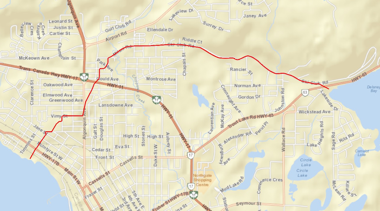
A number of locals think so including Roy Summers. He is a retired civil technician and a local historian. He is a very thorough researcher and an aficionado of historic maps. Years of dogged determination has helped Roy piece together what was in this area from a geologic and historic perspective. He is also a member of the Friends of the La Vase Portages. He thinks Champlain took the historic portage from Trout Lake to Lake Nipissing was along Ski Club Road, crossing Chippewa Creek and turning southwest towards Timmins St. and the present North Bay waterfront. There is evidence; it is identified as a historic portage on an 1883 survey. (Some think Cassells St. to Trout Lake Rd. may have been the direct route but its roots are later in North Bay’s history; it was the development road to Trout Mills [a working lumber mill] at Armstrong Beach.)
 Mr. Summers has unearthed many, many maps, studied the literature and diaries of those leaving behind records and images of the Nipissing Passageway, which includes a number of ways to reach Lake Nipissing. The La Vase portages is a 14 km/8.7 mile trek, in length, with three portages totalling 2.7 km/1.7 miles, it is one of three possible routes. Parks Creek, 10.7 km/6.7 miles, has five portages of 1.9 km/1.2 miles; (known as Ojibwaysippi) via a series of small lakes, (the “Cove” beach/Camelot Lake), is another. And the “shorter,” but not forgotten ‘North Bay and Trout Lake Rd.’ historic portage, 6 km/3.72 miles with no portages.
“These different routes were used by first, the extensive Amerindian trading network and then the French and English explorers and the voyageurs. These routes were described many times in writing between 1620 and 1845. Almost all of them have the documentation (maps, field notes and journals) stored in various archives, but there is no evidence of Champlain using the La Vase portages.” He points to the “league,” a historic unit of measure (which varied in definition) as another piece of evidence for an alternative route. “In many notations where the portage length is in leagues the distance more closely matches the historic portage route along Ski Club Rd. to the waterfront.”
But for Champlain the North Bay Board of Trade (now Chamber of Commerce) started promoting his arrival through the La Vase portages as early as 1925. That was the year North Bay became a city, an early milestone. The celebration was called “Old Home Week” and the extensive program acknowledged the prestigious explorer’s visit and the La Vase portages. The first commemorative plaque erected in 1925 (and since refurbished) is on Lakeshore Drive near the garden/bait enterprises. The hoopla continued, fast forward to 1961 and the next historic plaque on the east side of Highway 17 at Dugas Bay (there was a roadhouse there at one time, attracting many tourists). Then in in the 1975 the Chamber published Murray Leatherdale’s ‘Nipissing form Brule to Booth,’ a book highlighting the age of exploration and development within the Nipissing Passageway. Other plaques and a cairn have been erected at 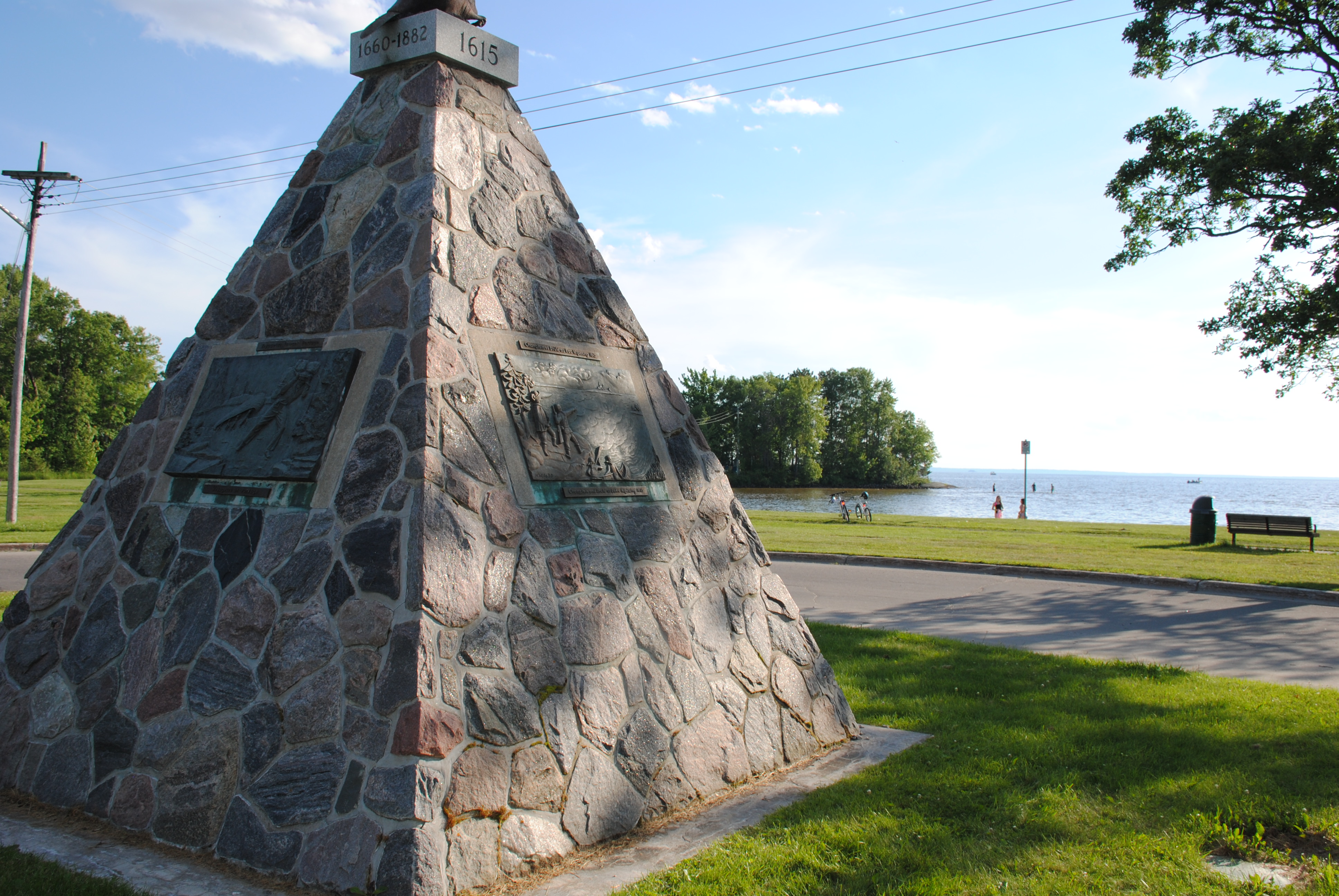 the end of Premier Rd. at Champlain Park. For years, since the early North Bay Board of Trade, through to the present, a variety of community groups have tried to promote, protect and conserve the La Vase portages. The “hey day” for the utilization of the La Vase portages was for approximately forty years when the North West Co. (NWC) operated La Ronde House on the small island at the end of Premier Rd., before amalgamating with the Hudson Bay Co. in 1821. It was during the time of Alexander Mackenzie of the NWC, one of Canada’s greatest explorers. He did use the La Vase portages. The fur trading company maintained a water control dam at the upstream end of the third portage to float the large freighter canoes.
Champlain the Promoter
The translated diaries (by H.P. Biggar) of Samuel de Champlain survive in his ‘Voyages,’ a detailed chronological narrative, edited for the French public. (And that is part of the mystery, what is lost in the translation?) In the early 1600’s, the ‘Voyages’ were public relations documents aimed at keeping Champlain’s activities in the forefront of French imperialism. The French were actively exploring many other areas of the world and New France was not the most important of their ventures. Champlain does not identify or describe what would have been the La Vase portages. But maybe he didn’t want to. The crossing is an arduous task at the best of times.
As one of Champlain’s many historical biographers, Kenneth Windsor, suggests: “Champlain was deeply discouraged sometimes by the prospects of the colony and the behaviour of the natives, but the ‘Voyages’ were no place for the expression of private or personal feelings.” His reports had to be favourable, for he needed a steady source of financial backing for his explorations.
There are many misunderstandings about the great explorer, in an article by Douglas Hunter in the highly respected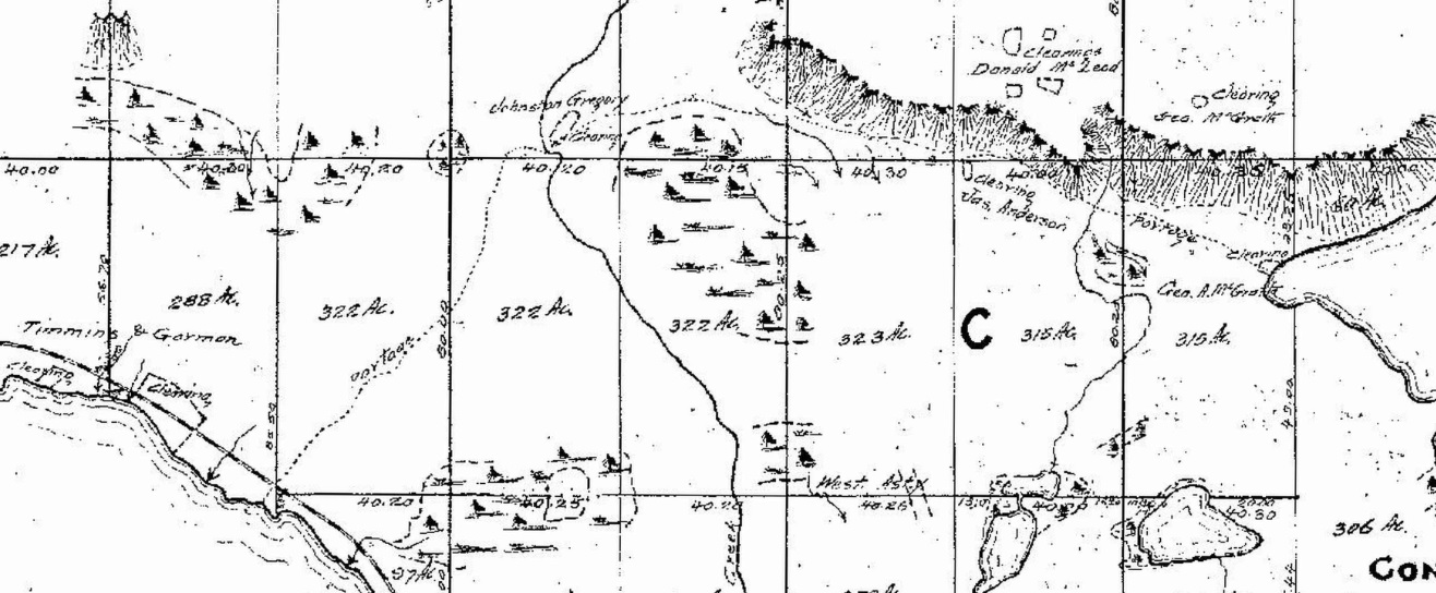 ‘The Beaver’ journal, (Jan. 2005), the researcher says: “Champlain’s portage route still hasn’t been fully analyzed – by giving the ‘Voyages’ a close reading and actually inspecting the portage terrain – it has been plagued by erroneous assumptions.” In 1618, (post visit to Lake Nipissing) Champlain proposed to the Paris chamber of commerce that “One may hope to find a short route to China by way of the River St. Lawrence…it is certain that we shall succeed in finding it without much difficulty.” Hunter says, “How much of that bravura was salesmanship on which Champlain knew he couldn’t deliver, and how much was genuine conviction on his part, is up for debate.”
In his ‘Voyages’ he says: “We passed through several lakes, where the savages carry their canoes.” Champlain is describing the then 14 portages along the Mattawa River. Upon arrival on the shore of Lake Nipissing he starts his journal entry with: “Where we rested two days .” There is no mention of the portages or where he “rested.”
Champlain previously had heard of the Nipissings from one of his guides, Étienne Brulé. This tribe was known by others as the “sorcerers,” and were well known for their supposed magical powers for creating lasting curses. “They gave us a very kind reception and were in goodly number, they are a race who cultivate the soil very little.”
He describes the natives’ existence and relationship to the landscape. “During the time I was with them, the chief of these people and others of their head men (medicine men) feasted us on several occasions, according to their custom, and took the trouble to go fishing and hunting in order to entertain us as daintily as they could. There are a great number of very pretty islands (Manitou Islands) and the north side of the lake is very pleasant (Meadowside); there are fair meadows for pasturing cattle and many little streams discharging into the lake (Duchesnay, La Ronde, Little Sturgeon Creeks).” He was definitely not describing the La Vase area.
Within the book by Murray Leatherdale, the author utilized much of Morris Bishop’s work of 1948, ‘Champlain the Life of Fortitude,’ again there is no link between Champlain and the La Vase portages.
Surveyed Historic Route
Alexander Niven was an “all-star” surveyor for the Province of Ontario. There is a historic monument dedicated to his achievements just west of Cochrane. His meridians became the legal boundaries for townships in northwestern and northeastern Ontario. He surveyed Widdifield Township (which amalgamated with North Bay and West Ferris in 1968).
Niven’s biographer, Kim Emerson, was contacted. “Despite the times and rudimentary equipment his surveys are incredibly accurate. He was a stickler for details and his survey notes prove why he was such a great surveyor.” Niven also identifies the La Vase portages in his West Ferris Township survey.
The amount of detail is very evident on the 1883 survey including the precise location of the escarpment and the expansive wetland below that still exists, surrounded by homes, today. Most of these roads do not fit a standard grid pattern and are indicative of what was a trail. From east to west, in a WNW direction, the historic route reflects the starting point at Armstrong Beach through the pedestrian culvert, it follows Ski Club Rd., through O’Brien St. to the McKeown/Milani extension, where it crossed Chippewa Creek (here it changes direction from NE to SW) at its narrowest and most tranquil location. (As an option, during the spring runoff Chippewa Creek could have been navigated by the smaller canoes of the time; these were not the larger voyageur canoes.) Turn on Mary, Doran and Murphy Streets and the route would have crossed Highway 11/17 on to Highland to Algonquin Ave., turning somewhere on to Vimy St., to Beattie St. through the Bourke Playground where you can see the trail running from NE to SW, on to Bloem where it meets Jane St. (see the steps of the trail). On to Cormack, descending the series of glacial beaches where it meets Main St. W. You are close to the condominiums at the waterfront. Along shoreline, in front of the “condos” you will see a large boulder and the small beach. On land there is a cut away or dug bank where the trail/tote road emerged; in the water you will see the natural rock groin, more visible in the spring, ideal for launching canoes.
Because of the Chaudiere dams, Roy Summers says Lake Nipssing was two metres lower than present day levels. The beaches closer to the “government dock” would have been expansive and would have been better habitation areas when compared to the surrounding lowlands of the La Vase outflow.” The Nipissings of our area did not summer at the La Vase River, they stayed near the pickerel spawning grounds of Duchesnay Creek and this nearby portage.
If you asked 400 canoe trippers whether they would want to unload/load their canoes three times over a longer distance (14 km) where the conditions were “muddy” (French translation for La Vase) with beaver dams or a route that was high and dry and shorter (6 km) you would not be surprised with the preferred choice.
We can say the Nipissing Passageway can be defined as three, historic routes; there is no doubt about that. The best evidence is that there is no evidence at all regarding Champlain’s route to Lake Nipissing. It is all interesting conjecture.
Les Compagnons and the Friends of La Vase Portages have the right idea and are re-enacting the arrival of Champlain, at the end of Premier Road in North Bay at noon, Sunday the 26th. Perhaps the downtown waterfront might attract a bigger crowd, Champlain would approve. Just celebrate. Take a drive along Ski Club Rd.