Talon Chutes-Mattawa River versus Grindstone Point – Lake Superior
Not Road Pot Holes – The Natural Ones
by Back Roads Bill
A street pothole is a type of failure in an asphalt pavement, caused by the presence of water in the underlying soil structure and the presence of traffic passing over the affected area. These are spring time annoyances to our car’s alignment, wheel bearings and suspension.
 There are potholes in the natural environment as well, these are worth the visit. The landscape around us holds many secrets. You can drive, hike or paddle by and never know there is interesting pothole” just over there.” When you discover an anomaly detective work is required.
Our planet is estimated to be approximately 4.5 billion years old. It is difficult to comprehend but there certainly has been enough time for slow, continuous processes to mold and shape the Earth as we know it.
James Hutton, known as the” father of geology,” suggested that the Earth was much older and that processes occurring in the present were the same processes that had operated in the past, and would be the processes that operate in the future.
This concept became known as “uniformitarianism” and can be summarized by the phrase “the present is the key to the past.” It was a direct rejection of a past, prevalent theory that identified catastrophism, as the only process that could modify the surface of the Earth. Today, we know uniformitarianism to be true and acknowledge great disasters such as earthquakes, asteroids, volcanoes, and floods are part of a regular cycle of events that shape our landscape.
Potholes
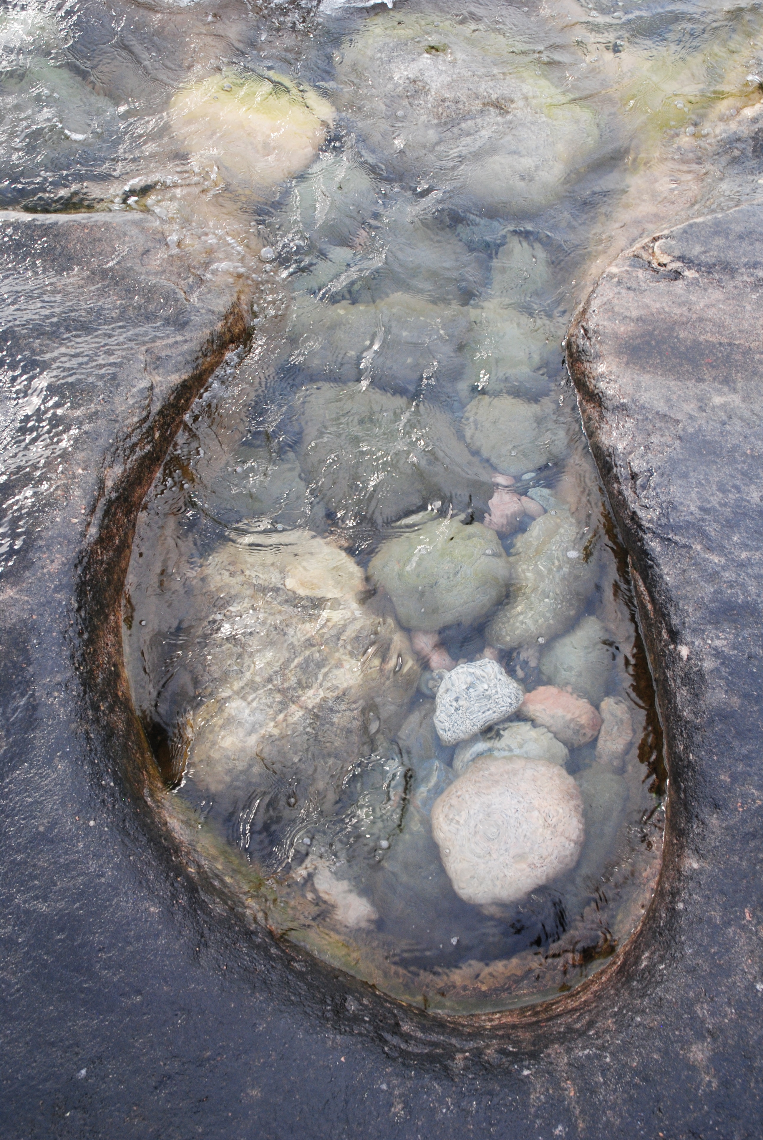
 There are potholes throughout Northern Ontario and are usually regarded as erosional features that influence the age estimates of rocks in which they occur. When you find one it looks like a jumbo or “raise bore” Redpath or Cementation mining drill has been at work.
Some are actively being shaped; some are evidence of past geomorphic processes. Potholes seem to be one of the geological features that discredit the idea of the flood of Noah’s time that occurred only a few thousand years ago.
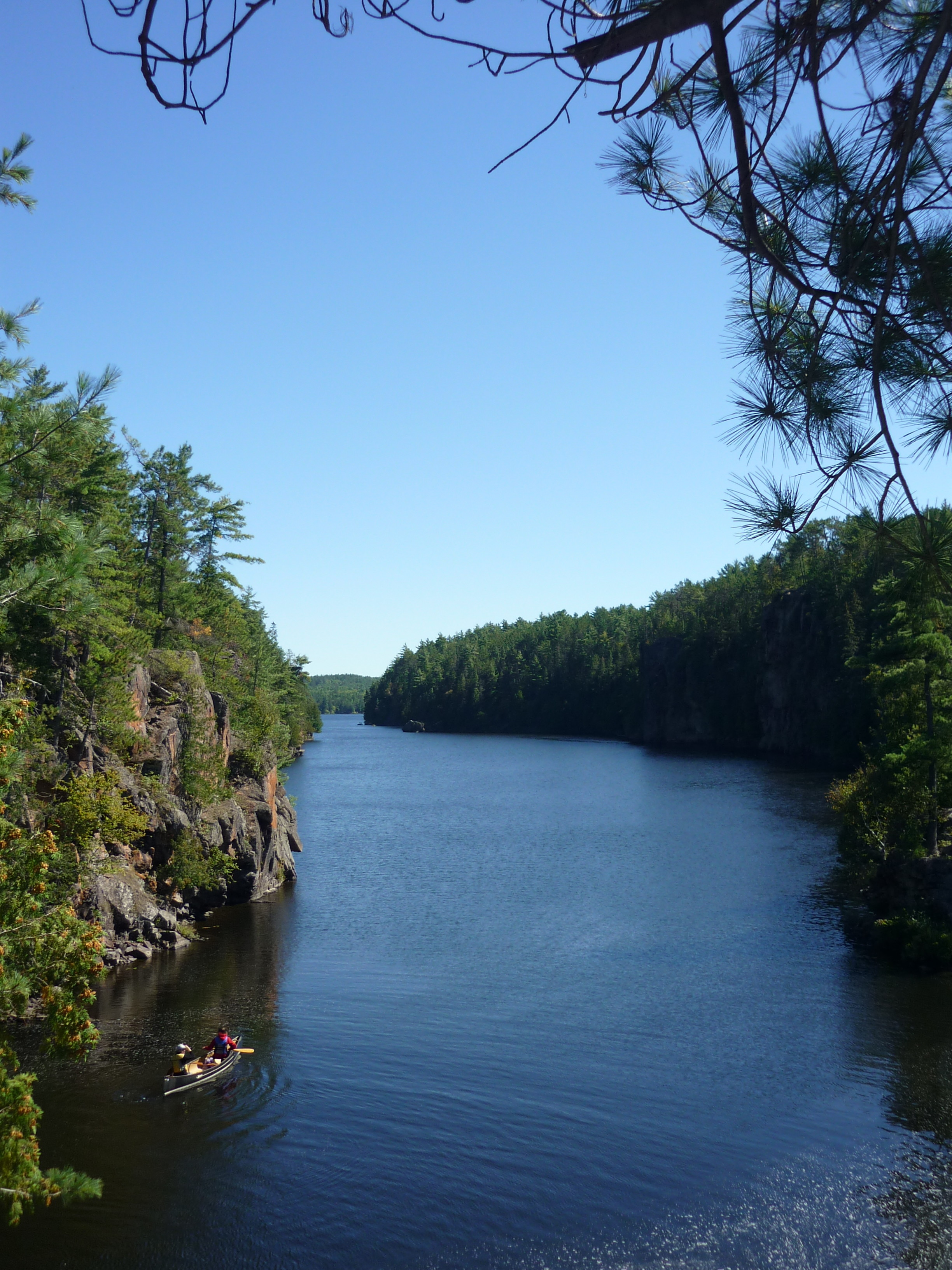
Locally there are a number of potholes at the Talon Chutes on the Mattawa River near Rutherglen. The other site is on Lake Superior near Old Woman Bay. It is an example of an “active” process where the potholes are now being carved out of the bedrock.
 In terms of process, potholes are formed by rotary currents inside the hole and by the vibration and abrasion of pebbles and stones (called “grinders”) by the water. These ever so gradually wear the holes deeper and deeper into the bedrock. It is a whirlpool effect of water and gyrating stones of varied sizes. As a result of the constant whirling of the granite stones, the potholes take on a remarkably symmetrical and round shape.
Dr. Eric Mattson, a Professor of Geography at Nipissing University says, “these potholes are the result of massive volumes of glacial melt-water draining through what is now referred to as the North Bay Outlet. This spillway was active from about 10,500 to 6,000 years before present. During this time, the Glacial Great Lakes drained through this area either in the main Mattawa River channel or the now abandoned spillway channels. At the same time the region was experiencing isostatic rebound (uplift due to the removal of glacial ice) and as a result, approximately 6,000 years ago, the Great Lakes began to drain out the St. Lawrence River. The outlet remains in use as the Mattawa River drains the Trout Lake water system however, the potholes are now perched well above the river.”
See for Your Self
The potholes at the Talon Chutes can be accessed by water or on foot. By water it is the Pimisi Bay picnic stop on Highway 17, just east of Rutherglen. The features are located off of the main portage trail at the downstream end on the high rock to the north or left. The best holes are two thirds of the way along the portage (from the downstream end) you will see an eastern white cedar stand on your south or left side. Walk to the south west through this small wintering deer yard. You will come out to the other drainage channel of the former glacial river. Look for the large, white (brucite) pothole and just a few metres to the north a deep pot hole you can actually stand in (a great photo opportunity). The larger pothole is being shaped by running water through the softer rock while the narrower and deep pot hole in the harder rock reminds us of the swirling and churning boulders that would have acted like a drill bit to form this hole. See WGS 84 N46° 16.902’ W79° 00.225’ or 17 T 653786 5127283 .
 On foot you will be starting on Highway 17, the Trans Canada Highway. The starting location is just west of the, now closed, Columbia Forest veneer mill. At the highway, at WGS 84 N46° 16.058’ W79° 00.661’ or UTM 17 T 653266 5125707 you will see the gate leading to the extensive aggregate pit. These gravel ridges are actually glacial moraines a reminder that all the Great Lakes once drained through this outlet, before the land rebounded and created a height of land separating Lake Huron from the Ottawa River. Anyway, don’t block the entrance to the pit and do not park here. Park across the highway, and slightly uphill; there is ample space on the highway’s right-of-way. The walking trail is the trail to the right or east of the pit entrance, it has a mound of dirt as the marker. You can see the road/trail on the map. The trail to the Talon Chutes is approximately a 30 minute walk or snowshoe. It is flat and at the beginning runs towards the NNE (you will come into contact with the back end excavation of the pit and you will have to walk around the edge of the pit) and then the trail veers northwards and then to the NNW. The former logging and mine road then takes a right turn and drops down the former glacial river shoreline to the chutes. You will be located at the western end or upstream end of the portage. You will see the control dam at this end.
 The Lake Superior potholes are found at Grindstone Point, accessed from Old Woman Bay on Highway 17. It is boat, canoe or sea kayak day trip or overnight. It is just south of Wawa, and there is camping within Lake Superior Provincial Park. By kayak or canoe it is 8 km. There is a campsite at Grindstone Point and you will paddle by Till Falls the highest falls in Ontario next to Niagara. For Grindstone it is N47° 43.878” W84° 58.683” or WGS 84 16 T E 651607 N5288416. There are some sea caves you can enter just past Grindstone Point. (There is also Potholes Provincial Park, a day use park, just north of Wawa on Highway 101; a very short walk and worth it; see http://www.ontarioparks.com/park/potholes .)
Most of the time we know we are going to experience driving into those annoying spring time, street potholes; instead check out the potholes on nature’s terms.