
Logging Chutes – So Different
Logging Chutes with a Difference
by Back Roads Bill
There are “neat” things to see on the back roads, some are well hidden; most of the time they disappear with the passing of time.
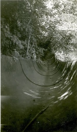 But not the steel logging chutes found near the Matabitchuan Generating Station (GS). Most logging chutes were made of hewn timber and were either dismantled or slowly decomposed. These are so different, a “diamond in the rough” when considering our industrial heritage.
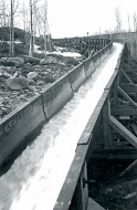
The use of chutes to transport logs was used extensively prior to the 1930’s. Logging chutes were primarily gravity chutes, used to transport logs down steep inclines to circumnavigate river obstacles. At the Matabitchuan River location a permanent steel chute was constructed more than one hundred years ago. Someone was thinking ahead.
Information supplied by Marcel Pelchat, Public Affairs Officer, Ontario Power Generation, “The station has been in service since 1910. It was acquired by our predecessor, the Hydro-Electric Power Commission of Ontario (Ontario Hydro), in 1944.” He said at one time there were two log chutes at Matabitchuan – one at the control dam (spillway) and one at the intake (generating station).
In the Beginning
historic shot
From a 1991 Ontario Hydro publication ‘Ontario Hydro’s History and Description of Hydro Electric Generating Stations’ it says the steel log slide was built in 1912 most likely because of the volume of red and white pine logs that were being cut in the Temagami Forest.
The Matabitchuan River runs almost parallel with the Montreal River, merging with it at the western shore of Lake Temiskaming. In earlier times the two rivers did not meet at the lake even before it was flooded downstream because of the control dams at Témiscaming. Huge sand bars extended out into the lake, and it is said that travel from Ontario to Quebec on the sand bars was possible. It is interesting to note that “Matabitchuan” means “the meeting of the waters,” (such as Mattawa) and is therefore a literal description of the setting for the two rivers.
A Hudson Bay Post was established at what was known as “the narrows,” as well as “The Old Fort”, and a Jesuit
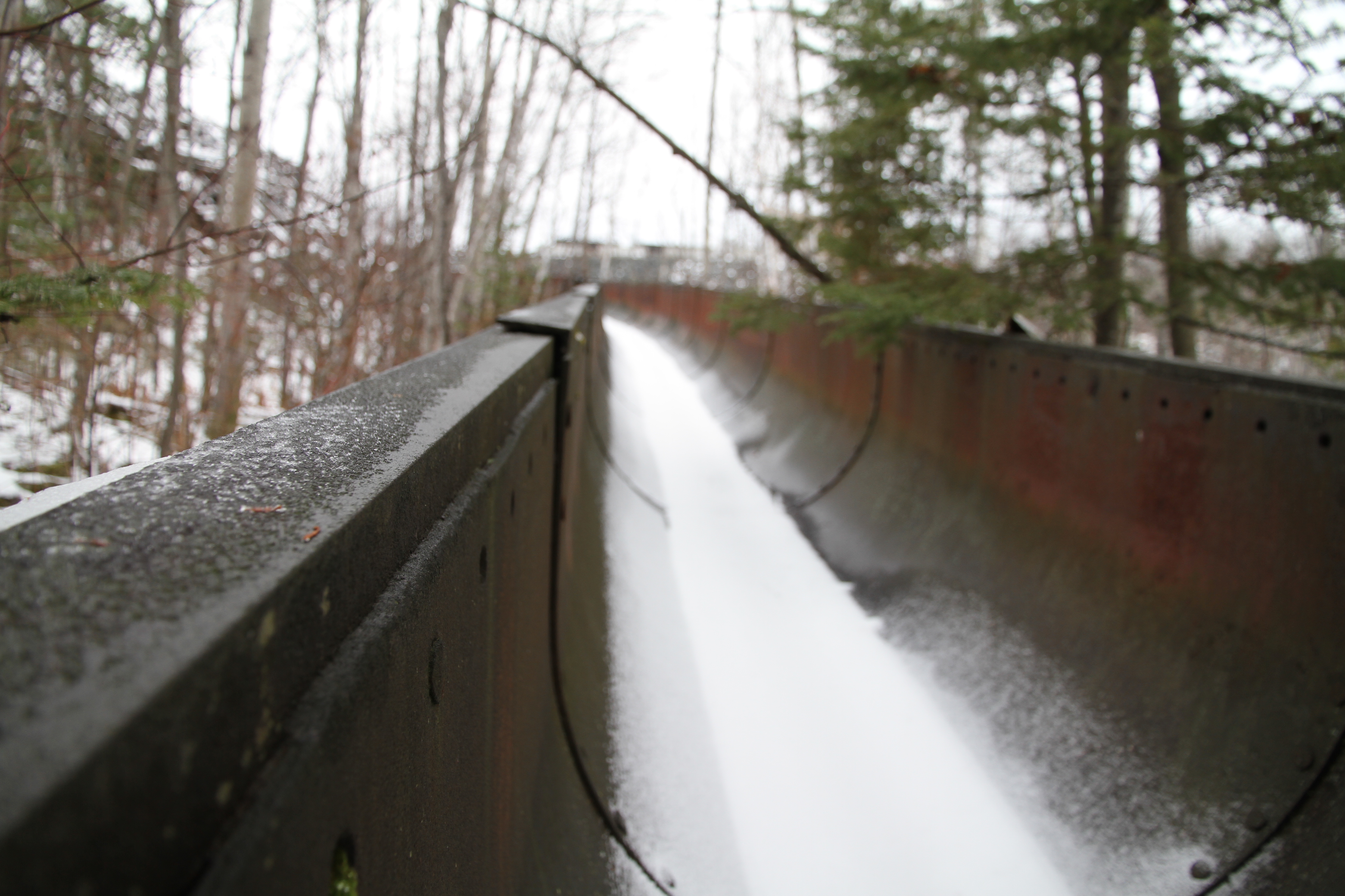
Present day
Mission was located on the Ontario side of the river. Recorded history of the River Matabitchuan dates back to 1688. The fort was utilized as a stop-over by Chevalier de Troyes during his 1686 expedition. As a mercenary, for New France, his mission was to remove the English from outposts along the Ottawa River to James Bay.
The earliest settlers located at the mouth of the Matabitchuan River. In the 1870’s, “The Farm” was established. Being a lumber operation, the farm was used to raise feed and to pasture their teams in summer. During the winter months it became a depot for travellers. Logs were floated on the two rivers and were taken in booms by tugboats to Témiscaming , located at the south end of Lac Témiscamingue (the early beginnings of Tembec).
The north soon became a prospector’s dream, with the silver rush in and around Cobalt. Land was staked for kilometers along both rivers, Silver Centre, located near the Lower Notch GS. (Montreal River; just north of the Matabitchuan) went from boom town to ghost town.
About this time E.A. Walberg recognized the potential of the rivers as a source of hydroelectric power, needed for the silver rush and on his initiative construction commenced on the Matabitchuan powerhouse in 1910. The moving of all materials, machinery, plant, and supplies from Témiscaming, a point on the Canadian Pacific Railway, to within about 0.4 km (0.25 mile) from the site of the plant, was done by means of scows and tugs up Lake Temiskaming.
The Powerhouse and Dam
The construction of the upper dam and the powerhouse is and interesting story. “All the powerhouse concrete was distributed from the mixer by wheelbarrows. A small crusher was used for crushing stone and boulders picked from the river bed. The sand was obtained near the mouth of the river
The dam being 0.8 km (0.5 mile) from any other portion of the works necessitated a complete separate plant for its construction. As there was no gravel of good quality nearby, stone had to be crushed, and a quarry was opened about 61 m (200 ft.) from the east end of the dam. All sand for the dam had to be hauled from near the mouth of the river up the 91 m (300 ft.) incline, and about 0.8 km (0.5 mile) across the upper level, where it was conveyed and dumped into the bins of the mixing plant.”
Logging was still the major industry in the valley, and the steel log slide was constructed from the lake to the river in 1912. With the advent of hydro-power came the established of a permanent community.
The Northern Ontario Power Company was taken over by the Hydro-Electric Power Commission of Ontario in 1944 and the demand for power continued to increase.
The steel log chute continued to be used. In 1947 the Gillies Bros. & Co. built a sawmill at Temagami (Cassels Lake – foundations remain, 4 km from the train station) to saw eleven million board feet per year to utilize a 400 square mile limit in that area. This mill was closed down and dismantled in 1958 but the logs continued to be floated 210 miles down the Ottawa River to their mill in Pembroke (Braeside). It was some time in the 1960’s when logs ceased to be flumed through these chutes. The power utility dismantled some of the sections and it is now incomplete. If you YouTube – ‘Ridge Runner Slide Ride – Blue Mountain’ you get an idea of the zigzag route of the Matabichuan chutes through the trees.
See the Chutes
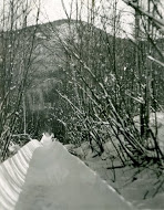 To see the steel chutes journey through Cobalt on Highway 11 B to North Cobalt. Take Highway 567, 38 km, SSE to the Lower Notch GS. (completed in 1971). Drive over the diversion channel, which is the Montreal River, a very interesting view of the dam, dykes and canal. Drive on another 5 km, SSW, to the Matabitchuan River GS. You will encounter some hills and you will be driving through an old growth white pine forest, called the Matabitchuan River Conservation Reserve. It was selected as a site representing old growth red and white pine forest communities. Drive past the powerhouse (automated in 1972) and up the hill over the penstock. The road will twist south to west or to the right. Park at the top of reservoir (access point to Fourbass Lake) and walk back down the hill to the first opening on the NW (left) side or N47°07’ 16.3” W79° 29’ 48.8” or WGS 84 17 T E 614014 N 5219728.
Associated with the conservation reserve are a few hiking trails that lead to Beaver Mountain Lookout and Copper Lake. These trails offer day and overnight hiking and canoeing opportunities. The expansive view from Beaver Mountain is worth the effort. You could snowshoe to the Beaver Mountain from near the steel chutes location (“halfway up the hill). Find online, the book, ‘Discovering Wild Temiskaming’ (“One day adventures and beyond”) by Murray and Vicky Muir; see the Nastawgan trails organization, www.nastawgantrails.org. See pages 58/59.
Time has stood still; you will appreciate the size of the slide. It is one of those hidden gems worth a look-see on a Sunday drive along the back roads.