Values and An Island – North Bay
The Seasons of an Island
Change Affects the Preservation of Values
by Back Roads Bill
As the seasons of the year change, so are the seasons of life and our values. This comparison comes from many cultures and many sources, the bible is one; Ecclesiastes 3:1-4 states,” To everything there is a season…”
The beauty of autumn has arrived, the days are shortening and the shadows are lengthening. It is the time to become responsible and to learn from the rewards the other seasons taught you.
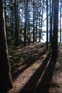
Camp Island is like an oasis and it represents many values to many people. Generations of Trout Lake’s residents and visiting canoeists have enjoyed day outings and camp overs. It is an elevated place with towering red pines and sandy soil with a natural connection to the clear waters below. When you walk amongst the shadows of the trees it has a special feeling, hard to describe, easier to feel. It was once known as Island ‘A,’ Kirkwood or Milne Island.
At the same time it was used for early Native groups and the myriad of voyageurs and explorers moving through the historic east-west Nipissing passageway, the preferred route into the interior of North America. Sand beaches with protected vantage points were preferred living areas for early aboriginal cultures; islands in particular have spiritual significance for the their view of world creation and these islands would have been occupied before European contact (1600’s). It is the largest of 19 islands on Trout Lake (112 acres/45 ha), located at the west end, it is the only island in the public domain. It is part of Mattawa River Provincial Park, a non-operating park.
A Little History
In 1902 the original patentee was a J.P Kirkwood it was acquired by William Milne a pioneer lumber baron who retained the island for his family as a summer cottage. Trout Lake was at one time called Milne Lake and the village at the west end of the lake was called Trout Mills (Armstrong Beach area).
Fred McNutt is the great grandson of William Milne. “The forest stands were so important that in 1950 a special order in council “declared a private forest reserve,” designation for the island, and the largest in the province. “Then in May of 1970 the family members who made the transfer of Camp Island back to the Crown had an agreement that the island would be preserved in perpetuity in a natural state for the use by the people of the area.”
For reasons things often change. In 2006 the provincial park (originally established in 1970) was expanded and Camp Island was included in the expanded park boundary on the basis the addition would “not preclude” consideration for future land claim purposes. Like his early family members he feels the North Bay is “fortunate to have such a recreational resource.” He would like to see the North Bay-Mattawa Conservation Authority (CA) manage the property. The CA’s Chief Administrative Officer and Secretary Treasurer, Brian Tayler said, “If we can provide help in the management of the island and it makes sense for all concerned then we would consider it.”
The “all concerned” includes the proponents of the Algonquin Land Claim. Within the draft agreement, in principle, Camp Island was identified as “settlement land.” A “working group” including Mr. McNutt, was established by the Ministry of Natural Resources and Forestry (MNRF) to “consider and address the future ownership and management planning options.” This includes the Algonquins of Ontario (Antoine Algonquin First Nation and Mattawa/North Bay Algonquin First Nation ) and Dokis and Nipissing First Nations. The Algonquins have said, in the past, they don’t intend to develop the island and want to preserve its archaeological values. There is a ‘Friends of Mattawa River Provincial Park and Camp Island’ organization; it is a group “committed to protecting this sensitive area from pending residential development and loss of use to the public.” On their Facebook page one post states: “…Our position is not that the Algonquins won’t listen but rather their negotiators and the government. The local Algonquin chiefs have been very open to discussion and listening. They have no power of change however…”
In process is a Stage 2 Archaeological Assessment, led by the MNRF that will aid “in identifying and increasing the knowledge base of the cultural heritage values.” A recent Stage 1 background study indicated a moderate to high potential for the discovery of First Nations archaeological resources. A Stage 3 may be recommended.
Unique Stone Structures?
The values have been known since 1973 through two reports, authored by archaeologists Allen Tyyska and James Burns. – one entitled, the ‘Faunal Analysis of the Camp Island Site.’
“In squares dug at Camp Island, we found artifacts suggesting the site’s use during at least two broad time periods, Middle woodland (any time between 700 B.C. and A.D. 1000) and Late Woodland(any time from A.D. 1000 to 1700) and “…it begins to appear that there may have been indian (sic) occupation all along he sandy part of the perimeter of Camp Island…”
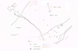
They also identified a “stone structure” in the back shore. “Essentially they comprise low stone walls (piled without mortar), pathways, stairways and pavements, arranged into structures of many different sizes, shapes and layouts.” They state, “Quite frankly nobody seems to know what these structures are. So we are dealing with something quite new. Most people seem to assume that they are somewhat ceremonial. This is possible. The depression (pathway) at Camp Island is clearly a pathway and the degree of compaction suggest a lot of people walked along it over the years.” They suggested further excavation.
If you can apply the scale on a map and know how to use a compass then you can find the stone structures. It is not as well defined as another site, known as the Palframan archaeological site, located on private land, near Dugas Bay (Highway 17 historic plaque) and the first La Vase portage. It is now protected by the city’s building bylaw regulations.
Mr. McNutt said, “I do not see the Crown is preparing to break the original agreement so I remain optimistic the essence of that agreement will be maintained.”
When we take the time to reflect upon the natural environment, we begin to observe a complex world cycling through patterns, phases and through stages of transition. We also quickly realize that nothing ever stands still; we can thank humankind for change. Maybe the working group will salute one of North Bay’s early pioneer families and again call it Milne Island (?).
We reflect on the seasons to luxuriate in the thought that there is springtime for Camp Island; for spring is the time when opportunities arise. “They” will figure out all the values and the best solution for an island that now rests as winter approaches.


