Bridging Time – Mattawa/Sault Ste. Marie
Forgotten Bridges Remain Today
Helping to Remember the Romans and the Great Depression
By Back Roads Bill
The Romans invented concrete (opus caementicium) and were great road and bridge builders. The finest roads the Romans built used deep roadbeds comprised of crushed stones for moisture control followed by a layer of capstones or pavers.
It is inevitable this summer; you will wait in line for the road construction flag person to eventually give the stopped traffic the go-ahead with the florescent green SLOW sign. Use the delay to reflect on the new and old concrete bridges and why jobs are important; something you have wanted to do anyway.
Presently, the economy is bouncing along like the bumpy road construction projects. During the Great Depression we took a major detour. Most of us cannot relate to the time when economic activity around the world came almost to a standstill.
In January 2009 as part of Canada’s Economic Action Plan, the $4 billion Infrastructure Stimulus Fund supported more than 4,000 projects as a short-term boost to the Canadian economy during a period of global recession; this included roads and bridges. Today the Ontario government’s Northern Highways Program will invest $513 million to repair highways and bridges in the north creating or sustaining hundreds of direct and indirect jobs. These programs sustain Ontario’s transportation network while strengthening the economy. You see both program signs as you approach the flag person and the STOP sign ahead; wait for what seems to be too long and then go through the road construction. The projects and the workers give local communities a real economic boost. (One of my earlier books was entitled ‘Boosting the Bay’ published by the North Bay and District Chamber of Commerce, “boosting” was an early economic term.)
Back then it was the federally funded relief projects being signed with provinces in late 1930. Thousands of men were hired to construct highways in remote areas of the province from temporary camps, named” Bennett Camps “after then-Prime Minister R. B. Bennett. This provided the necessary labour to open road links through vast expanses of wilderness in a relatively short period of time. Beginning in 1931, certain routes were designated as the Trans-Canada Highway. There wasn’t the same social umbrella as today. The government was forced to act and used its limited resources to create something innovative. Between 1929 and 1932, overall employment fell by 32% in the province. The government addressed itself to finding work for men, as women, then, stayed at home. . The unemployed wanted to work and would take anything they could get rather than go on relief.
It was a time to keep men off of the streets. It was thought camps would build up morale through work. Food, clothing, a bed and medical assistance would be provided. Another unstated reason for establishing the camps was to keep men from the influence of Communist agitators, part of the “Red Scare.”
Concrete Bridges – Heritage
There is not much left to show of the efforts of the highway era work camps. But some of the original bridges can be found not far from the current Trans Canada Highway.
Ontario had 37 camps; there was a highway “relief” camp (#17) in Calvin Township east of North Bay located at the Amable du Fond bridge (see the red pine stand, provincial park, brown gate, north side). Often men sent north from Toronto could not stand the rigours of camp life or the winters.
Bill Schorse of Corbeil recalls that his father was a clerk for the road contractor. “Alec owned the Ford dealership in Mattawa and at the time there weren’t many cars being sold.” Supplementing his income he transported supplies to the road sites in a Model ‘AA’ pickup. “One time, one of the relief workers hitched a ride back to the Calvin camp in a thunder storm. When the stranger asked what my father was carrying in the back of the truck; dynamite at the time, the door flew open and he was gone before the next words were spoken.”
The road work was done by horse and wagon. After the blasting of the rock cuts the “rock mucking and transportation was done by dragging stone boats, it was the dump truck of the day.” By the end of 1935, numerous factors combined which resulted in the termination of the highway camps. Often workers became agitated with the living conditions. Brief strikes took place at various locations but achieved nothing.
See the Bridges
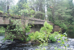
Two fine bridges remain as good, accessible examples and the concrete remains intact; it may very well there is no rebar (?). One is 18 kilometres east of the Big Mufferaw statue in Mattawa. It is just east of Klock’s Rd. and crosses Aumond Creek on the north side of the highway. It has a narrow, 14’ (4.2m) wide deck portion. Today’s highway is 30’ (9.1m) wide [ 15’ (4.5m) from the centre to the apron]. There is a an unofficial pull off and a well beaten trail to bridge You will see the original highway right of way is grown over by the presence of a large white pine tree.
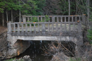
The other is located just east of Sault Ste. Marie. It is located west of Desbarats and east of the Highway 548 to St. Joseph Island/Highway 17 turnoff. Look just east of where the four-lanes begin. The bridge is on the south side of the highway. Climb down the bank and take a close look at the architecture and the width. See WGS 84 17 T E 271224 N 5135850 or N46° 20.254’ W83° 58.363’. A date stamp has not been found.
Roman concrete, like any concrete, consists of an aggregate and hydraulic mortar – a binder mixed with water that hardens over time. The aggregate varied, and included pieces of rock, ceramic tile, and brick rubble from the remains of previously demolished buildings. Reinforcing elements, such as steel rebar, were not used.
As an aside, the barricaded Stanley St. bridge, east of the Kate Pace Way pavilion at the waterfront, has a 1924 Munro date stamp in the abutment (SE end). You can see the traditional pillar design on the deck. This was the original road crossing the railway tracks before the Main St. (Constable Fred Lefebvre) overpass was opened in 1967. You can see how concrete deteriorates actively, as water percolates around the rebar, at the small Hammond St. (3rd Ave. E) bridge south of Fisher St. Another, old bridge, with the traditional pillar design, the John St. bridge is slated for refurbishment; it has been delayed by other municipal priorities. All of these bridges cross Chippewa Creek.
The road flag person won’t tell you about these forgotten bridges or how the Romans built the bridges to last. These bridges are not much of a memorial as it was a time we now would not like to know.


