Two for the Price of One – Nipigon
Two Destinations – Dramatic Ice Relief and a Railway Tunnel
Highway 11 – Nipigon – Winter and the Rest of the Year
by Back Roads Bill
You often hear the expressions “two is better than one,” “the more the merrier” or perhaps “good things come in pairs.” When you are exploring, two finds make for a good day; especially when they are so different but close to one another.
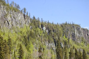
We have two Trans Canada Highways in Northern Ontario and they start in North Bay and meet again in Nipigon; that’s a story in itself. The present layout of Highway 11 along the east side of Lake Nipigon is a winding, two-lane paved highway with very narrow gravel shoulders. At the scenic lookout on the east side of Highway 11, 12 km south of Orient Bay, 41 km north of Nipigon you will see one of those blue bronzed Ontario heritage plaques.
It reads: “Here at Pijitawabik Bay and other Lake Nipigon localities ancient rocks of the Precambrian Shield were overlain by a diabase sheet formed approximately 1,200 million years ago. Erosion by water and ice removed the covering rocks and sculptured the sheet into rounded, flat-topped hills bounded by escarpments which rise in some places 152 metres above Lake Nipigon. The hills are separated by deep, narrow valleys. The towering pillars of the cliffs are the result of columnar jointing, a cooling phenomenon developed during the solidification of the magma. Frost action along the cracks in and around the columns causes splintering of the rock and occasionally the collapse of entire pillars, leaving the imposing palisades seen here.” It is one of the best examples of dramatic relief in the province. You can see these as you drive along the highway or take the hiking trail along the top.
The Palisades trail, also known as the Palisades of the Pijitawabik [PEE-GEE-TUH-WAW-BIK] is a must-do hike providing views from some of the highest points in Northwestern Ontario. The trail along the high cliffs has been recently constructed with stairs and bridges to protect the terrain from erosion. It solves one of those nagging questions, “how do I get up there?”
The trail starts at the parking area and climbs of 150m over 1.6 km to the summit of the palisades; that is the most difficult part, it is not the terrain it is climbing all those stairs; no different than an intense stair master workout. The trail then follows along near the edge of the cliff but views are only found at the four lookouts along the way. The 4.6 km trail ends at the Cascade Falls which you saw from the highway down below. On the return trip follow the Browse Lake loop by taking the left-hand fork shortly after heading back on the trail. From the lake continue on to the junction of the main trail and back down the series of stairs to the bottom. You are 183 m above the Lake Nipigon lake level.
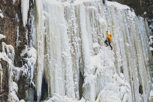
The Pijitawabik Palisades are world-renowned as one of the top three ice climbing destinations in all of North America. Having 110 waterfalls with heights over 40 meters (132 feet) and freezing up to 10 meters (33 feet) thick, the Palisades boast the greatest concentration of climbable ice east of the Rockies.
While they are better known for the dramatic ice formations during the winter, the remaining seasons provide several “abyss waterfalls” creating stunning views of a different kind. Take a pair of binoculars.
Drive 38 kilometres northeast of Nipigon on Highway 11 turn right at the blue & white highway sign identifying the trail entrance. The parking area is located 200m from the highway (WGS 84 16 U E419549 N5462601 or N49° 18.651’ W88° 06.410’). If you are into geocaching check www.geocaching.com so you can find the geocaches located along this trail.
Tunnel Vision
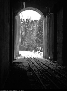
Just up the highway (northwards) you can walk through a 300 m abandoned rail tunnel that is believed to be the longest in eastern Canada.
We don’t have the opportunity to go through tunnels much. A tunnel is an underground passageway it takes you somewhere; tunnels are important then. There are few railway tunnels in eastern Canada. We most often think of the colossal tunnelling effort through the western mountains by the Canadian Pacific Railway (CPR) syndicate of the late 1800’s.
We know the well-known black and white photograph featured in the introduction of Pierre Berton’s ‘The Last Spike;’ all those men with the beards and moustaches and tall hats. It is the ceremonial driving of the CPR’s last spike into the rail bed in the Craigellachie Mountains within British Columbia’s interior. Some of the major figures of Canadian history are there, Donald Smith, William Van Horne and Sir Sandford Fleming.
Construction of the transcontinental railway spurred the birth of Canada; in fact, all of North America was undergoing change in the 19th century. Immigrants, especially Europeans, poured in to settle the land. The CPR came first. There was a need for more than one national railway. Highways were not a vision at the time.
Canadian National Railway (CNR), incorporated on June 6, 1919, took form through a series of mergers between 1917 and 1923, uniting several older and financially troubled railways, many of which had been built between 1850 and 1880.
By 1919, the Intercolonial, Canadian Northern, National Transcontinental and Grand Trunk Pacific had become part of a government railway system known as the CNR. It was during this time the Kinghorn sub line from Longlac to Nipigon and westward to Thunder Bay was constructed, rivalling the CPR.
Fast forward, during the 1980’s railways in Canada felt the impact of the USA-Canada Free Trade agreement and a period of deregulation and downsizing followed. Some short lines were abandoned. The last train to pass through this beautiful section of track along Orient Bay was in May 15, 2005, and by May 2010 there was nothing but a roadbed and ties to remind us of the line.
Apparently, there is an interesting vortex created in long tunnels. Local Nipigon historian Jim McMahon told ‘Community Voices,’ “The local residents at Macdiarmid have told me they were trained from youth that if a train came along while they were in the tunnel they were to lay down as far from the rail bed as possible to avoid being sucked under the train.”
From Nipigon drive east on Highway 11/17 and then turn left onto Highway 11. After you drive for about 53 km, watch on the right (east side) for a utility building where you can park (N49° 25.502’ W88° 07.516’ or WGS 84 16 U E418399 N5475315). If you reach the turnoff to the Rocky Bay First Nation in Macdiarmid you have gone too far, eastward, by about 1.5 km. From your parking spot cross the highway and walk 50 m down the road to Jumbo’s Cove. Turn right (north) when you reach were the tracks were. You will soon see the entrance to the tunnel. It’s a good idea to bring a flashlight.
Most of us won’t go ice climbing. This vantage point affords the opportunity to see this extreme sport. You can view it from above or below. And it is not every day we get to walk through an abandoned railway tunnel. These two destinations are within 15 km of the other, have a look at our natural and cultural heritage.


