
Watch for the Animals Crossing – Slate Islands (Terrace Bay)
Watch out for Animals Crossing!
by Backroads Bill
One minute you’re concentrating on fishing the green and the black, the next you see a caribou approaching your boat. And that’s not tackle tangled in their rack.
A trip to the Slate Islands can satisfy the senses of the outdoors enthusiast in a number of ways. For the angler there is the excitement of landing and experiencing some of the finest red-finned lake trout anywhere. There are no caribou crossing road signs, but there should be, they’re everywhere. Keep your camera ready as they swim from island to island. For the kayaker/canoeist it is an opportunity to explore the natural and cultural heritage within the protection of a group of islands. You are constantly landing and looking at all there is to see.
The Trans Canada Highway, east of Thunder Bay, sweeps through rock cuts past small Canadian Shield lakes and red cliffs, skirting the cold sparkling waters of Lake Superior.
As you pass through Rossport, Schreiber and Terrace Bay you get glimpses of them. Grey masses offshore, rising up on the horizon – the Slate Islands. The lake trout and caribou are close at hand.
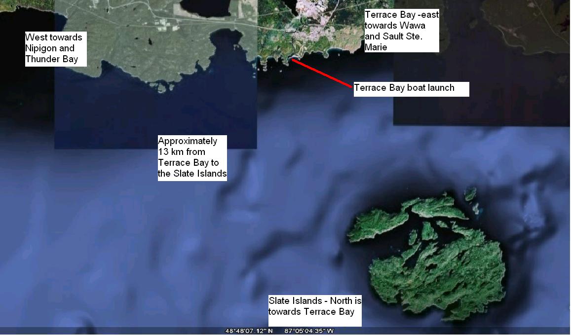
Isolated and uninhabited, the Slates are a circular cluster of two major and five smaller islands part of a large structure formed by the impact of a large meteorite. But the islands, 13 kilometres (9 miles) off of Terrace Bay, are the home for some of the best, natural lake trout in all of Lake Superior, and the most southerly herd and the greatest density of woodland caribou in all of North America.
For adventuresome anglers it is an opportunity to enjoy more than “just a little fishing.” And if you’re beachcombing you could be as fortunate as the person who found one of only two artifacts remaining from the Edmund Fitzgerald which sunk November 10, 1975. Years later, and hundreds of km from the wreck, a life ring washed ashore on the Slates. A marine museum has offered $35,000 for the find. It is now on display at nearby Neys Provincial Park between Marathon and Terrace Bay.
Doug Caldwell has been coming to the Slates for more than 40 years. The former Kimberly-Clark pulp mill employee is also an Auxiliary Coast Guard member. He maintains one of the few charters that will take you to the Slate Islands.
His uncle, Ed, was a lighthouse keeper on the islands for 31 years, manning the highest vantage point on all of the Great Lakes. When he first went there in 1928 the brass lamp had a double wick, operating much like a Coleman light, but much bigger.
He also knows the fish and the caribou. “You have to troll where the green meets the black,” said Doug. That is where the green hue near the shoals meet the deep water of the underwater cliffs. “Keep your boat along that line as you cruise the shoreline dropoffs.” As Doug says, “that’s the only guide you’ll need.”
“You are amongst hundreds of caribou in a very unique habitat,” explains Doug at one of the few retreats on the islands. The buildings are old commercial fishing shacks that have been maintained by locals and available to anyone who needs a safe haven. “You can see them crossing between the islands at the closest points of land and at anytime.”
Fishing is good especially off of the points where feed is kept active by the currents and angling success occurs throughout the day. One to five pounders are the norm and bigger lakers are found on the offshore reefs. It’s not hard to get your limit in a very short time.
Catches verify the fishery is very productive. A former volcanic rim has created an circular arrangement of islands. The geologic formation is a natural hatchery and sizes indicate a growing fishery. Small fish are found in the protected waters of the islands with larger 10-20 pounders in the open waters.
The lake trout fishery here is not in jeopardy, in fact over harvesting by anglers is not a problem. Commercial fishing is not permitted within 1.6 km (one mile) of the islands.
Caribou Watching
You notice a difference immediately you come ashore to prepare a shore lunch or set-up camp. Well-worn caribou trails, better than some man-made hiking paths, are everywhere criss-crossing the forest.
You also notice the marks of plant eaters. Despite what appears to be dense bush the vegetation at ground level is sparse.
The caribou here are different than the tundra caribou of the far north. On the barren lands both male and female have antlers but on the Slates approximately 60% of only the males have antlers. The males are also smaller, almost the same size as females.
Although the Slates have provincial park status it is mainly used by anglers, sail and power boaters from Minnesota, Wisconsin and Thunder Bay, and kayakers and canoeists who make the adventuresome crossing of open water from Terrace Bay or use the shuttle service. There are limited park facilities. It is a destination to come to, prepared.
Back to Doug. He has watched wildlife researchers “wrestle the caribou” during taggin projects. He has seen a few “trophies” in the water during the recruitment of brood stock by the fish culture section of the province. (Many of the caribou have an assortment of research tags in their racks, called “Christmas trees.”) He recognizes the importance of the islands for scientists and resource managers.
“The red-finned lake trout is some of the finest broodstock in the province.” Spawners are used in the nearby Dorion fish hatchery operated by the ministry of natural resources. “This native lake trout population provides the genetic variability necessary for higher survival and production rates and increased vigour.”
He explained that before 1907 there were no caribou on the Slate Islands. “According to a former lighthouse keeper, they came in the winter crossing the frozen ice, only to be stranded before spring break up.” About the time caribou on the Slates were starting to prosper, all the less isolated herds on the north shore of Superior were becoming extinct. Because of the large population, caribou have been corralled, tranquillized and airlifted to many mainland locations.
The caribou on the Slates have the ultimate defence – miles of open water – a challenge to wolf and man alike. But Mother Nature has played a major management role for large-scale population fluctuations.
“To explain the die off you have to understand the eating habits of the caribou,” said Mr. Caldwell. “They eat summer foods similar to moose and deer but in the winter the caribou will not eat buds or twigs.” In the winter caribou survive entirely on lichens from blowdowns (reindeer mosses and tree lichens or “old man’s beard”).
He said caribou cannot understand rationing at all, they eat until full. “Ultimately the caribou face starvation every winter.” Strong winter winds knock down trees full of the vital lichens in their upper branches. Deadfall is everywhere and the branches are picked clean by browsing. But there are years when the wind does not blow long or hard enough and the caribou stand and wait, and finally die.
Humankind lets nature take its own course on the Slates, in the natural regeneration of a valuable lake trout fishery and the feast and famine cycle of an insular herd of caribou. Plan for a visit and stay awhile. You will be back.
Other Information
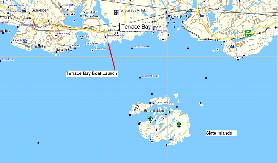
Regional scale map
If you go to the Slate Islands you will see caribou and you will see magnificent scenery particularly within the rock formations. Fishing is a bonus. You will want the paper topographical maps, 1:50 000 042D10 (PIC ISLAND) and 042D11 (SLATE ISLANDS), the Slate Islands
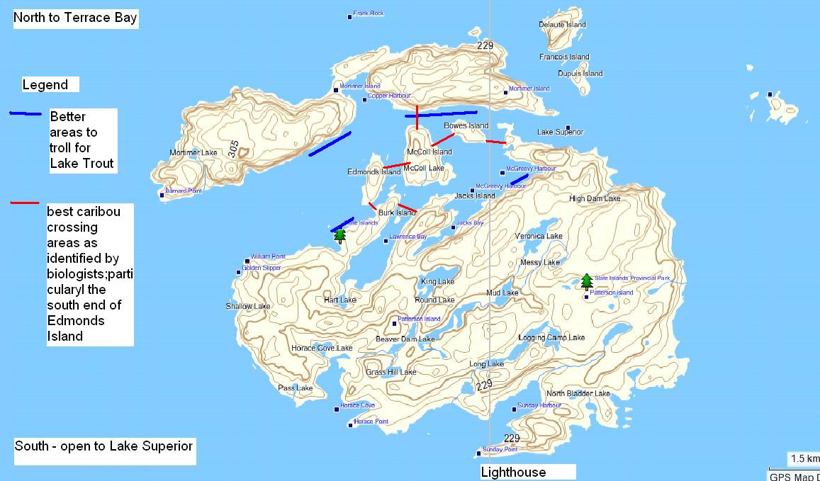
Island overview scale map
are on the border of two maps. Remember to read the tab regarding maps. The following are WGS 84 map datum coordinates. The paper maps, unless updated, will most likely (unless upgraded) will be NAD 27. Do the conversion with your GPS or mapping software if you are using the paper map. Look at the comments section for each waypoint in the detailed .gpx file. You will have a detailed tour in and around the islands!
- There are two theories on the formation of the Slate Islands: the islands are of volcanic origin with subsequent faulting, folding and erosion; the islands are the central uplift cone of a crater resulting from a meteorite impact
- Troll near the shore in 15-25’ of water. 12 lb spider wire fusion (green) fishing line and three-quarter ounce gold and blue/silver Little Cleo lures work well
- You can see the mill as you cross to the Slate Islands. Nearby Terrace Bay had the dubious distinction in the early 80’s of having the worst pulp and paper mill in Ontario – this from Greenpeace citing the outpouring of effluent from the Kimberly-Clark pulp mill directly into Lake Superior. Much has changed and the mill is now an environmental leader in environmental control. The mill dates back to 1948.
- You can see the mining adits (horizontal, exploratory shaft) on Patterson and Mortinmer Islands, these were developed in 1899 and 1901. On the south side of the Mortimer Island it is on the east side of Copper Harbour/Lambton Cove (two local names for this bay) that almost divides the island. See 16 U E 498095 N 5392 It is closer to where the bay narrows on the east side.
On the far west point of William Point on Patterson Island the mining adit) is situated near 16 U E 496011 and N 5389089. It is slightly around the point look closely through the leaves.
- If you go ashore at the north end of McColl Island you will find remains of coal and the coal docks utilized during the commercial fishing and logging days of the 1930’s. At 16 U E 498919 N 5391601
- The lighthouse on the south side of Patterson Island was constructed in 1902. Check the weather before you go. Your destination is Sunday Harbour. As you head towards William Point on the southwest side of Patterson Island watch for the arches and flowerpot-like rock formation
- A number of distinct disjunctive plant species exist in this harsh, wind swept environment including two rare finds, Drlyas drumondii a species that is usually found on the southwest Pacific coast and Polygonum vivporum or as it is commonly called “smartweed” a delicacy to the Inuit and usually found in the high arctic
- The Slate Islands caribou have the smallest body and antler size and the lowest degree of sexual dimorphism of any caribou in North America. This “insular” population has most probably had no “gene flow” with other mainland populations for more than 50 years (A small number of wolves were identified in 1994-1996; these wolves now seem to be absent as per studies). The caribou population are most likely part of a “boom and bust” cycle with the population ranging from 150 to 450 with major “dieoffs” at approximately five year intervals
- See the many raised beaches evident of higher Lake Superior levels thousands of years ago and related to the last retreat of the continental glaciers at WGS 84 Zone 16 U E 498102 N 5389909 you can see the orange and white coloured volcanic intrusions at 16 U E 498618 N 5391215 along the west shore of McColl Island
Access
Google Earth – shore to islands
A trip to the Slate Islands is a real treat and the following information will add to your experience. Take a few days or a week.
The Slate Island experience is best for the spring, summer and fall seasons.. Fishing is best in the spring and fall. Camping and exploring in the summer. As mentioned in the story be prepared. Crossings are on occasion delayed by the weather.
Being shuttled across to the Slate Islands is your best best.
You can kayak or canoe the 13 km from or launch your boat at the launch in Terrace Bay. (I have done the former but won’t again it is a long point A to B paddle with water conditions something to be more than aware of). (I have been with Doug on a number of occassions.
There are designated camping spots and safe anchorages on the islands. Two good camping locations are located at the northwest tip of Patterson Island across from the east end of Mortimer Island. On Patterson Island the two sites are 16 U E 500272 N 5391566. Just to the south of this campsite is another tucked away in Fisherman’s Cove 16 U E 500385 N 5391222 This also a good mooring location.
Two other campsites are on the south side of Mortimer Island. One is on the eastern side of the island, beyond Copper Harbour/Lambton Cove that almost bisects Mortimer Island. It is approximately one third of the way down this shoreline on a small protruding sand spit. See 16 U E 499113 and N 5391911 . The other camp site is on the western side of Copper Harbour/Lambton Cove see 16 U E 497662 N 5392183 .
* There remains a number of Crown land cabins, open to the public, remembrances of the commercial fishing days. Most are in a state of disrepair, but one remains, called ‘Come and Rest’ situated near the southwest tip of McColl Island. It has had its share of tending loving care. It is open to the public and has been restored by a number people who are “fans” of the Slate Islands. It may be available when you arrive. You can camp there or use the cabin and the sleep cabin.
Visitors just come and go. It is one of those rare places where people give and respect the environment they are experiencing and the ‘Come and Rest’ cabin. There are log books going back more than forty years, sign in and leave a memory. It is a special place. Leave something behind for the next visitors. It is also a good mooring area. 16 U E 498627 N 5390496. See the map.
For more regarding accommodation and restaurants and other services along the Terrace Bay – Rossport stretch of Lake Superior Highway 17 contact Caribou Charters in Terrace Bay at 807-825-3719 or www.cariboucharters.com.